Below are links to downloads of the most current version of the bedrock geologic map of the Middlesex Fells, an explanation of the map, and an explanation chart of the map units. Also included are tabulations of existing ages shown in chart and table form as well as a diagrammatic cross section. This project is part of my ongoing research in the Dept. of Earth and Climate Sciences at Tufts University, Medford, Massachusetts. For more about me, Prof. Jack Ridge, go to: http://ecs.tufts.edu/people/ridge.htm.
Please be aware that the map and its explanations are ongoing research that is updated periodically as new information is obtained, interpretations change, and revisions are posted. This is truly a work in progress.
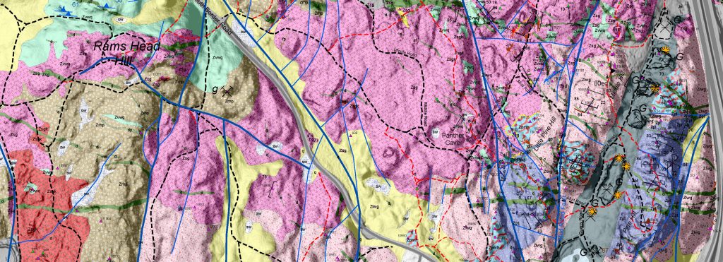
Please be aware that new names for rock formations are used here where there is field evidence that existing units may contain units of different ages or have separate mappable facies. Some of the names used here have not been approved yet as official formation names but are used for me to keep track of what I think are separate units. As I accumulate new radiometric ages some of these new names may be solidified or abandoned. For example, we now know that the Dedham Granodiorite of earlier studies has five separate plutonic bodies that are traceable in the field and have radiometric ages that are either ~609 Ma or ~596 Ma. New names, as indicated on the map, have emerged from this analysis. Other units on previous maps that have been split are the Westboro Formation, Middlesex Fells Volcanic Complex, and Lynn Volcanic Complex of previous maps.
If you decide to use information on the geologic map, please reference it as follows with the date the web site was accessed:
Ridge, J.C., 2025, The Bedrock Geology of the Middlesex Fells Reservation and Adjoining Boston North Quadrangle in Middlesex County, Massachusetts, USA: Map and Explanation, 289 p., 1:4600 scale map (last update June 1, 2025). https://sites.tufts.edu/fellsgeology/ [when the map was accessed]
Any comments or suggestions that you would like to send to the author can be sent to Jack Ridge at : jack.ridge@tufts.edu. I welcome feedback and questions.
Most recent posting update: June 1, 2025
Downloads of bedrock geologic map and map explanations:
Bedrock map: Link to: FellsBedrockJune1-2025.pdf
Full map explanation: Link to: FellsGeologyFullExplanationJune1.pdf
Poster of map explanation: Link to: FellsGeolPosterExplanationJune1-2025.pdf
Map unit chart: Link to: FellsGeologyUnitChartJune1-2025.pdf
Rock unit age tabulation: Link to: FellsAgeTabulationJune1-2025.pdf
Diagrammatic cross section: Link to: DiagrammaticCrossSectionsJune1-2025.pdf
Radiometric Age Summary: Link to: FellsRadiometricAgesJune1-2025.pdf
Special Document:
Volcanic Features of the Middlesex Fells: Link: Fells Volcanic Rock Features
Information about the map and other downloads:
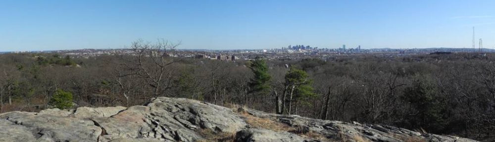
Why a new map? The bedrock map of the Fells is an out growth of my interest in the geology of the Middlesex Fells that was acquired during many hikes in the area. It is a research project that started as a way of satisfying my curiosity for what I was seeing along trails in the Fells. Although there are abundant rock exposures (outcrops) in the Fells, the rocks are not easy to diagnose. Rock types are often obscured by lichens and and weathering. In addition, the fine-grained rock units are difficult to analyze without using a microscope and there are no fossils to assist with age determinations. Published geologic maps did not satisfy me. After viewing the rocks and the existing maps, it became clear that the Fells had a much different and more detailed story to tell, one that was more interesting than I had imagined. The Fells was just begging for an accurate and detailed geologic map and because of abundant bedrock exposures it is much easier to map than adjacent developed areas. It is the low hanging fruit north of Boston!
Modern Mapping Tools: Mapping in the Fells has been done in much more detail than is normal for geologic maps. Mapping in the field was at a resolution of less than 2 meters, and when printed at 100%, is compiled at 1:4600. (This is just the largest scale that will fit the east-west dimensions of the map on a 44-inch plotter.) Most geologic maps in the U.S. are published by the U.S. and state geological surveys at 1:24,000. I felt that the geology had much more to offer at a large scale, and with modern GPS (Global Positioning System) and GIS (Geographic Information System) technologies, and LiDAR (Light Detection and Ranging) imagery, this is all possible. The beginning pages of the full map explanation (link above) will give you all the information you need on how the area was mapped, especially if you are a GIS nerd. For his patience in guiding me through the mine field of GIS, my former colleague at Tufts, Jacob Benner (now at Univ. Tennessee, Knoxville), has my everlasting gratitude. Thanks Jake!!
A Map in Progress: I am constantly refining the map and some interpretations may be revised or refined as I get more numerical age data. For the most part, however, the most important field relationships seem to be worked out. Formation names may change as I consolidate them with existing map units in adjacent areas, especially mapping to the east. Mapping in the Fells that still remains to be done is on the islands in the Winchester Reservoirs. Subsurface drill core data has not yet been incorporated into the map yet.
Sialic Fine-grained Rocks (Felsite): In making a geologic map of the Middlesex Fells, one of the most challenging things to get a handle on in the field is the exact character of fine-grained sialic igneous rocks or what have generally been called felsite in the Boston area. Determining whether they are volcanic (formed as ash, other pyroclastic deposits, or lava flows) or are shallow (subvolcanic) plutonic bodies is difficult in the field. Many of these determinations must be made using a microscope and thin sections. I have included for download above a special document, which is a compendium of volcanic rock textures and structures that I have used to identify volcanic rock types in the Fells. This includes features seen in hand specimens and thin sections. It is essentially an image gallery showing the best examples. This will give you information on how I interpret the fine sialic rock formations.
Differences from previous maps: In many places on my map, formations that appear on old geologic maps have been split and renamed. The last geologic map of any detail was a preliminary map by Clifford Kaye of the U.S. Geological Survey in 1980 (Kaye, C.A., 1980, Bedrock geologic map of the Boston North, Boston South, and Newton Quadrangles: U.S. Geological Survey Miscellaneous Field Investigation Map MF-1241, scale 1:24,000), which was intended to replace parts of an older, smaller scale map by Laurence LaForge (LaForge, L.,1932, Geology of the Boston area Massachusetts: USGS Bulletin 839, 1:62,500). The new map, with its new formation designations and subdivisions, takes issue with the lumping of many rock formations on the Kaye map, where subvolcanic and volcanic rocks were grouped together, granites and granodiorites were lumped that we now know have significantly different ages, the formation of hornfels was not fully appreciated, and the subdivision of sedimentary and metamorphic clastic units was not recognized. The map is a work in progress and is progressing with further mapping north and east of the Middlesex fells into other parts of the Boston North Quadrangle in Malden, Melrose, Wakefield and Saugus.
There are many new ages, in addition to those previously obtained by Francis Macdonald and his students and Martin Ross that are incorporated into the map. Many papers on Boston area geology published in the last 25 years, especially those of Meg Thompson, (professor emeritus, Wellesley College), have been very helpful, and provide the basis for numerical ages and time periods for many rock formations in the Boston area.
I am also in the early stages of applying a technique new to the Fells, which is paleomagnetism. So far, this work has been the measurement of the anisotropy of magnetic susceptibility (AMS) in rock units. This type of magnetism depicts a magnetic fabric that can give insights into how some rock units formed. So far my students (Katherine Lowe, ’14; Jenna Mello, ’21; Lara Williams, ’22) and I have collected samples of metamorphosed rocks in which the magnetic fabric matches field measurements of deformation features. In the summer of 2020 we also collected samples of dolerite dikes for both a susceptibility fabric analysis and to determine ancient magnetic field directions that may help place age restrictions on the rocks and some of the faults that cut across dikes. The AMS fabrics in the youngest set of dolerite dikes reveal the direction of magma flow in the dikes, which is vertical.
Acknowledgments: Mapping in the Middlesex Fells immerses one in mostly igneous and metamorphic rocks. I freely admit that igneous and metamorphic petrology, and the field mapping of these rocks, is not the primary area of my training, which is in glacial and Quaternary geology, general geologic field mapping, and paleomagnetism. In a short period of time, since about 2010, I have had a rapid education in local geology that would not have been possible without many discussions and field excursions that have not been without arguments, disagreements, and agreements with some geologic friends. They have all provided very helpful insights from other field areas. Some of them have a memory of past geologists, past field conference trips, and field experience in the Fells, and they all have a ton of unpublished information going back 5 decades. I am very much in debt for the many discussions and field trips I have had with Bert Reuss (emeritus prof., Tufts Univ.), Lindley Hanson (emeritus prof., Salem State Univ.), Francis Macdonald (formerly Harvard University, now professor at the Univ. California at Berkeley), Meg Thompson (emeritus prof., Wellesley College), Richard Bailey (professor, Northeastern University), and Martin Ross (professor, Northeastern University). They have been very encouraging and patient. Special thanks also to James Crowley at the Isotope Geology Lab at Boise State University in Idaho for his careful analysis of the radiometric ages of rocks in the Fells. I would also like to thank the Department of Earth and Climate Sciences at Tufts University for its support on this project. I especially thank Jacob Benner (Univ. Tennessee, Knoxville) and Carolyn Talmadge (Tufts University) for repeatedly helping me with Geographic Information System (GIS) technology.
Enjoy the Middlesex Fells geology and enjoy the Fells map!
Jack Ridge