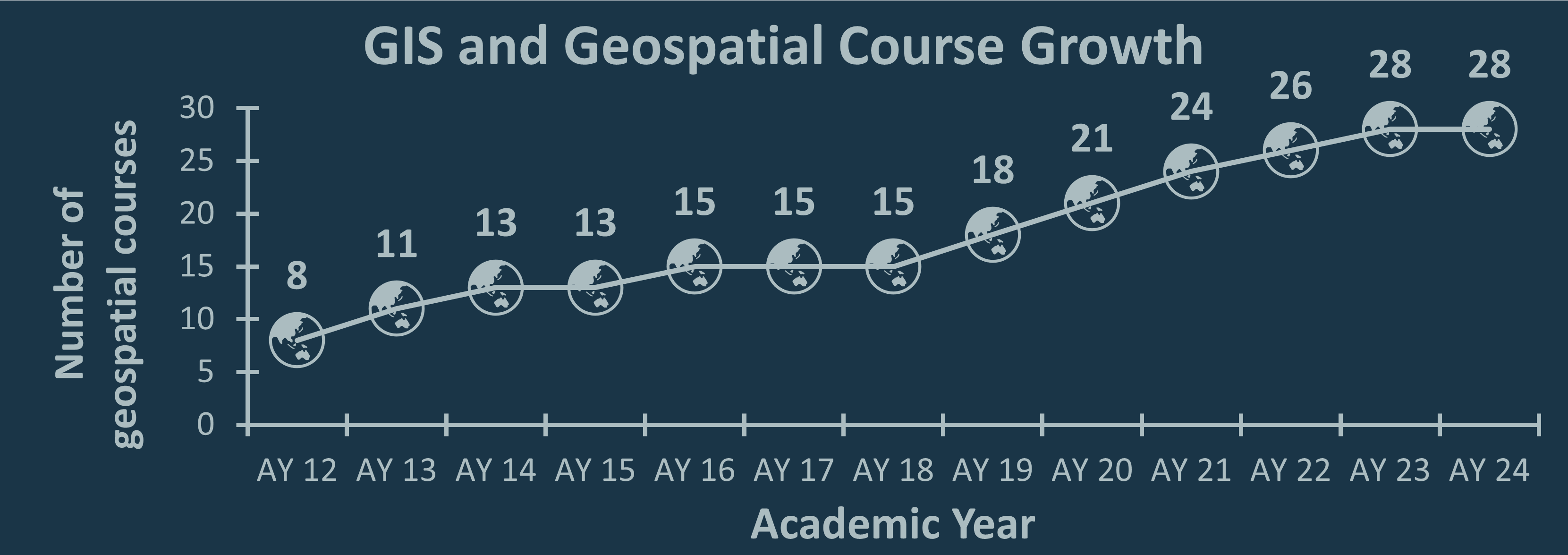
Education is the cornerstone of GIS at Tufts. Since 2003, we have steadily grown our course offerings and adapted to changing technologies.
See information about our 28 courses below and click on specific courses to learn more about them:
Introductory GIS Courses
▸ CEE 187: Geographic Information Systems
▾ CEE 187: Geographic Information Systems
Instructor: Dr. Laurie Baise
Email: Laurie.Baise@tufts.edu
Semester offered: Fall
Spatial analysis with Geographic Information Systems (GIS), including their use for engineering applications. GIS data structure and management, techniques for spatial analysis. Applications including seismic hazard, water resources, and environmental health. Laboratory exercises in GIS. Prerequisites: ES 56 or CEE 156 or graduate standing.
▸CLS 125/ HIST 179/ UEP 103/ARCH 175: Geospatial Humanities
▾CLS 125/ HIST 179/ UEP 103/ARCH 175: Geospatial Humanities
Instructor: Ian Spangler, Assistant Curator of Digital & Participatory Geography, Norman B. Leventhal Map & Education Center at the Boston Public Library
Email: Ian.Spangler@tufts.edu
LinkedIn: https://www.linkedin.com/in/ispangler
Semester offered: Spring
The humanities are becoming spatial, or maybe we are finally realizing that they always have been. Geography – the stuff of “where,” which encompasses material as concrete as the dirt on the earth to concepts as ephemeral as “space” and “belonging” – informs not only how texts, maps, and other objects are produced, but how we encounter them as readers and users. In recent years, improvements in computing technology and advancements in publicly-accessibly digital archives have harmonized with interest among researchers to conjure a nascent field of study focused on the derivation and analysis of structured geographic data from books, letters, paintings, and much more.
This course will explore the geospatial humanities, learning its techniques, studying its objects, and testing its limits. The course introduces geospatial theory, methods, and technology for applications in the humanities in past and present settings. We’ll sometimes use the term “GIS” (short for geographic information systems) to describe these geospatial tools. Typically, GIS is defined as a combination of software, data, methods, and hardware with capabilities for manipulating, analyzing, and displaying spatial data. We’ll explore spatial data structures, data creation, basic geodesy, spatial analysis, cartographic visualization, and more. Using the software ArcGIS Pro, you will learn how to use these tools effectively. Just as importantly, by incorporating insights from critical archival studies, indigenous and decolonial mapping, feminist geography, and more into your mapping practice, you will learn how to use them intentionally.
For more info on the course, visit Ian’s course GitHub: https://itspangler.github.io/geospatial-humanities-s2024/syllabus/#course-summary
▸ DHP P207: GIS for International Applications
▾ DHP P207: GIS for International Applications
Instructor: Dr. Marcia Moreno-Báez
Email: marcia.morenobaez@tufts.edu
LinkedIn: https://www.linkedin.com/in/mmorenobaez/
Semester(s) offered: Summer, Fall, Spring
This course will introduce students to the use of geospatial technologies, data and analysis focusing on applications in the international context. The course gives primary emphasis to the use of geographic information systems (GIS) for data creation, mapping, and analysis. It will also cover the use of global positioning systems (GPS) for field data collection and mapping; cartography for high quality visualization of conditions, issues, and analysis results in a given locale; and the use of map mash-ups and crowd sourcing in the international arena
▸ GIS 101/ENV 107/INTR 81: Introduction to Geographic Information Systems
▾ GIS 101/ENV 107/INTR 81: Introduction to Geographic Information Systems
Instructor: Dr. Rebecca Shakespeare, Dr. Alexandra Thorn, Dr. Sumeeta Srinivasan
(Instructor is dependent on GIS section)
Email(s): rebecca.shakespeare@tufts.edu, sumeeta.srinivasan@tufts.edu, alexandra.thorn@tufts.edu
Semester(s) offered: Fall, Spring
Broad foundation of Geographic Information Systems theory, capabilities, technology, and applications. Topics include GIS data discovery, data structure and management; principles of cartographic visualization; and basic spatial analysis and modeling. Assignments concentrate on applying concepts covered in lectures and class exercises to term projects in each student’s fields of interest.
▸ HIA 219: Spatial Epidemiology (Online)
▾ HIA 219: Spatial Epidemiology (Online)
Instructors: Dr. Shikhar Shrestha
Email: shikhar.shrestha@tufts.edu
Semester offered: Fall
In public health, place matters. Place is a close reflection of the social and economic deprivation and environmental exposures that can result in significant health disparities that are manifest in health outcomes, including morbidity and mortality. While uses of geographic information systems (GIS) and spatial epidemiology have increased steeply and steadily within the public health sciences during the past two decades, they are still in their infancy. In health disparities, nutrition, disease prevention, and health services research, this is particularly evident. More than an estimated 80% of health issues have a spatial component; however, only a small fraction of research studies include a focus on the geography of health and spatial associations of putative exposures, access to care, and health outcomes. This course will provide students with the basic skills needed to obtain, analyze, and decipher spatial data in GIS, using a variety of examples from public health, nutrition, urban development, and the US Census Bureau.
▸ MCM 591: GIS for Conservation Medicine
▾ MCM 591: GIS for Conservation Medicine
Instructor: Carolyn Talmadge, Data Lab Services Manager, Research Technology, Tufts Technology Services
Email: Carolyn.Talmadge@tufts.edu
Semester offered: Fall
This course will introduce students to the fundamental concepts of the Geographic Information Systems (GIS) as it relates to the one health paradigm and veterinary health. This course is designed for novice GIS students with specific focus on mapping and spatial analysis for human, animal, and environmental health applications. Tutorials include vulnerability analyses of animal habitats, monitoring disease outbreaks for public health, calculating deforestation and land cover change, suitability analysis for Ebola treatment centers in Liberia, site analysis for alternative energy sources, and many more. Technical topics to be covered include GIS data discovery; GPS field data collection; data structure and management; principles of cartographic visualization and design; and basic spatial tools, analysis and modeling. Classes will consist of both a lecture segment and an in-class activity/demonstration. Students will complete weekly tutorials or project assignments and conclude the semester with a final mapping/analysis project of their choosing. This course is open to all students and faculty from the Veterinary School.
▸ NUTR 231: Fundamentals of GIS for Food, Agriculture, and Environmental Applications
▾ NUTR 231: Fundamentals of GIS for Food, Agriculture, and Environmental Applications
Instructor: Dr. Alexandra Thorn
Email: alexandra.thorn@tufts.edu
Semester offered: Fall
This is a full credit course that introduces Geographic Information Systems (GIS) to address the many problems of agriculture, food systems, and the environment. This course will provide students with the fundamentals to begin using GIS in research and applied projects. The primary purpose of this course is to provide students with sufficient understanding of GIS science and software programs to be able to conduct a simple project independently.
▸ PH 0262: GIS for Public Health
▾ PH 0262: GIS for Public Health
Instructor: Dr. Thomas Stopka Dr. Laura Corlin, Dr. Shikhar Shrestha
Email: Thomas.Stopka@tufts.edu, Laura.Corlin@Tufts.edu, Shikhar.Shrestha@tufts.edu
Semester offered: Spring
In public health, place matters. Place is a close reflection of the social and economic deprivation and environmental exposures that can result in significant health disparities that are manifest in health outcomes, including morbidity and mortality. While uses of geographic information systems (GIS) and spatial epidemiology have increased steeply and steadily within the public health sciences during the past two decades, they are still in their infancy. In health disparities, nutrition, disease prevention, addiction, environmental health, and health services research, this is particularly evident. More than an estimated 80% of health issues have a spatial component; however, only a small fraction of research studies include a focus on the geography of health and spatial associations of putative exposures, access to care, and health outcomes. This course will provide students with the basic skills needed to obtain, analyze, and decipher spatial data in GIS, using a variety of examples from public health, nutrition, environmental health, urban development, and the US Census Bureau.
This course includes in-person lectures, lab assignments, and guest speakers, as well as individual assessments on approaching specific problems through visualization of spatial data, spatial analytics, and spatial epidemiological perspectives.
▸ UEP 232: Intro to GIS
▾ UEP 232: Intro to GIS
Instructor: Dr. Sumeeta Srinivasan , Dr. Rebecca Shakespeare
(Instructor is dependent on GIS section)
Email: Sumeeta.Srinivasan@tufts.edu, Rebecca.Shakespeare@tufts.edu
Semester(s) offered: Summer, Fall, Spring
This course will focus on introducing students to the use of geographic information systems in the urban/suburban/metropolitan environment. Students will learn to work with urban spatial databases (including data sets pertaining to land use/land cover, parcel records, census demographics, environmental issues, water, transportation, local government, community development, and businesses). Technical topics to be covered include finding and understanding sources of information for metropolitan spatial databases, integration of data from a variety of sources, database structure and design issues, spatial analysis capabilities, data quality and data documentation. While learning GIS skills, participants will complete a mapping/analysis project of their choosing. Prerequisite: None.
▸ UEP 294-28: GIS Boot Camp & Qualitative GIS
▾ UEP 294-28: GIS Boot Camp & Qualitative GIS
Instructor:Dr. Rebecca Shakespeare
Email:Rebecca.Shakespeare@tufts.edu
LinkedIn:https://www.linkedin.com/in/rshakesp/
Semester(s) offered: Summer, Fall, Spring
This course will focus on introducing students to the use of geographic information systems in the urban/suburban/metropolitan environment. Students will learn to work with urban spatial databases (including data sets pertaining to land use/land cover, parcel records, census demographics, environmental issues, water, transportation, local government, community development, and businesses). Technical topics to be covered include finding and understanding sources of information for metropolitan spatial databases, integration of data from a variety of sources, database structure and design issues, spatial analysis capabilities, data quality and data documentation. While learning GIS skills, participants will complete a mapping/analysis project of their choosing. Prerequisite: None.
Advanced Geospatial Courses
▸ DHP P289: Advanced GIS
▾ DHP P289: Advanced GIS
Instructor: Dr. Marcia Moreno-Baez
Email: marcia.morenobaez@tufts.edu
LinkedIn: https://www.linkedin.com/in/mmorenobaez/
Semester offered: Spring
Check out this StoryMap on what you’ll learn in Advanced Geospatial Modeling.
▸ GIS 102 / Env 197: Advanced GIS
▾ GIS 102 / Env 197: Advanced GIS
Instructor: Dr. Sumeeta Srinivasan
Email: Sumeeta.Srinivasan@tufts.edu
LinkedIn: https://www.linkedin.com/in/sumeeta-srinivasan-3b35134/
Semester offered: Spring
Design and use of spatial information systems to support analytical modeling in research and geospatial processing for professional development, research, and practice. Topics include the structure and integration of large data sets, relational database management, development of spatial data, integration of data into models and geoprocessing techniques, and basic scripting to support geospatial modeling. Prerequisites: GIS 101, UEP 232 or equivalent.
▸ UEP 231: Interactive Web Mapping
▾ UEP 231: Interactive Web Mapping
Instructor: Dr. Pinde Fu, Adjunct Faculty, Team/Project Lead at ESRI
Email: Pinde.Fu@tufts.edu
LinkedIn: https://www.linkedin.com/in/pinde-fu-2617b86/
Semester offered: Summer
The internet, web, and mobile technologies have significantly changed the way geospatial information is acquired, transmitted, visualized, analyzed, published, and shared. This course aims to provide students with a deep understanding of Web GIS principles, along with the latest geospatial, cloud, and mobile technologies shaping modern Web GIS applications. This course will cover ArcGIS Online and ArcGIS Enterprise cloud GIS platforms, as well as out-of-the-box app builders including ArcGIS Instant Apps, StoryMaps, Experience Builder, Dashboards, Survey123, and Field Maps. Students will utilize HTML, CSS, ArcGIS Arcade, ArcGIS Maps SDK for JavaScript, and webhooks to enhance the user interface and functionality of the out-of-the-box web and mobile GIS apps. Additionally, this course will explore spatial-temporal data, 3D web scenes, spatial data science, and emerging technologies including virtual reality (VR) and augmented reality (AR) within the context of Web GIS.
Course Goals: Provide students with a comprehensive and up-to-date overview of Web GIS, including the basic concepts, principles, related fields, and frontiers. Inspire students with the broad and real-world applications of Web GIS, especially in e-Government and e-Business. Equip students with state-of-the-art technical skills needed to build Web GIS applications and the knowledge required to manage Web GIS projects.
▸ UEP 235: Advanced GIS
▾ UEP 235: Advanced GIS
Instructor: Dr. Sumeeta Srinivasan
Email: Sumeeta.Srinivasan@tufts.edu
LinkedIn: https://www.linkedin.com/in/sumeeta-srinivasan-3b35134/
Semester(s) offered: Fall, Spring
This course is intended to be for students from any discipline with an interest in advanced geospatial modeling and spatial analysis. It explores topics in Database Management such as SQL and UML and work with a variety of spatial data formats. It will also build on previous knowledge of Geographic Information Systems (GIS) applications. Students will learn spatial analysis methods including raster analysis, suitability analysis, spatiotemporal statistics, Geostatistics and network analysis. The lab component will focus on the use of ArcGIS. Automation using ArcPy and/or Model Builder will be an essential component of many of the lab exercises. Students will work on a either group or individual projects based on their own interests. Prerequisites: A full semester introductory GIS course or its equivalent.
▸ UEP 236: Spatial Statistics
▾ UEP 236: Spatial Statistics
Instructor: Dr. Sumeeta Srinivasan
Email: Sumeeta.Srinivasan@tufts.edu
LinkedIn: https://www.linkedin.com/in/sumeeta-srinivasan-3b35134/
Semester offered: Spring
This is a first course on spatial data analysis. Students will learn about global and local spatial autocorrelation statistics, cluster analysis, principal component analysis, point patterns, interpolation, hotspot analysis and space time analysis. They will also learn to use a variety of regression techniques for spatial data including spatial, autologistic and geographically weighted regressions. Several open source software will be introduced: Geoda, CrimeStat, SAM, CAST and R. The course will have weekly lab exercises and a final project based on the student interests. Prerequisite: Introduction to Statistics or equivalent./p>
Remote Sensing & Drones Courses
▸ ENV 0121: Drones for Data Collection, Mapping & Analysis ★NEW★
▾ ENV 0121: Drones for Data Collection, Mapping & Analysis ★NEW★
Instructor: Jon Caris
Email: Jon.Caris@tufts.edu
LinkedIn: https://www.linkedin.com/in/joncaris/
Semester offered: Fall
Drones for Field Data Collection, Mapping & Analysis is a course designed to teach students drone flight operations for the collection, mapping, and analysis of drone imagery. Data analysis will draw on techniques and methods that include photogrammetry, structure from motion, image processing, mapping, and aerial photography and videography. The course encourages teamwork, curiosity, critical thinking, perseverance, and creativity, as well as best practices, ethical conduct and etiquette regarding fieldwork and community-based research. We seek motivated students who want to learn practical techniques for acquiring and analyzing aerial data, as well as students who may be skeptical about drone technology. We encourage all students to think critically about their engagement with drones and to help us improve the academy’s approach to teaching and research with this emergent and disruptive technology.
▸ MCM 1011: Drones -- Unmanned Aircraft Systems (UAS) for Field Data Collection, Mapping & Analysis
▾ MCM 1011: Drones -- Unmanned Aircraft Systems (UAS) for Field Data Collection, Mapping & Analysis
Instructor: Jon Caris
Email: Jon.Caris@tufts.edu
LinkedIn: https://www.linkedin.com/in/joncaris/
Semester offered: Spring (1/2 semester)
Drones for Field Data Collection, Mapping & Analysis is a course designed to teach students drone flight operations for the collection, mapping, and analysis of drone imagery. Data analysis will draw on techniques and methods that include photogrammetry, structure from motion, image processing, mapping, and aerial photography and videography. The course encourages teamwork, curiosity, critical thinking, perseverance, and creativity, as well as best practices, ethical conduct and etiquette regarding fieldwork and community-based research. We seek motivated students who want to learn practical techniques for acquiring and analyzing aerial data, as well as students who may be skeptical about drone technology. We encourage all students to think critically about their engagement with drones and to help us improve the academy’s approach to teaching and research with this emergent and disruptive technology..
▸ UEP 189 / CEE 189: Introduction to Remote Sensing
▾ UEP 189 / CEE 189: Introduction to Remote Sensing
Instructor: Dr. Magaly Koch
Email: Magaly.Koch@tufts.edu
Semester offered: Fall
This course introduces students to the use of satellite imagery and other remotely sensed data for urban and environmental analysis. The course will emphasize practical applications of remote sensing for understanding human-environment dynamics. Students will get a thorough overview of remote sensing data sources and understand which sources are appropriate for which applications. Lectures and labs will cover the workflow of processing sensing data for environmental analysis, starting with data acquisition and moving on to image georeferencing, image enhancement and filtering, image classification and basic image analysis.
▸ UEP 294/ CEE 0293: Advanced Remote Sensing
▾ UEP 294/ CEE 0293: Advanced Remote Sensing
Instructor: Dr. Magaly Koch
Email: Magaly.Koch@tufts.edu
Semester offered: Spring
This advanced course deals with Earth Observation (EO) satellites, EO data products, and applications. It is a project-oriented course with several hands-on activities. Students will learn advanced techniques to extract meaningful information from remote sensing imagery: monitoring and assessing land change, time-series analysis, target detection, spectral mixture analysis, decision support tools, change detection for disaster monitoring, advanced classification algorithms. A final project is required that involves a real-world application of advanced image processing or remote-sensing physics. Students will develop their own projects, tailored to their research interests. Prior coursework in Geographic Information Systems, remote sensing or statistics is recommended.
Programming and Visualization Courses
These are select data science and visualization courses that earn credit towards the Spatial Data Science certificate:
▸ UEP-0194-09: Introduction to Python (1 SHU)
▾ UEP-0194-09: Introduction to Python (1 SHU)
Instructors: Dr. Andreia Martinho & Pramesh Singh
Semester(s) offered: Fall, Spring
This is a required prerequisite for UEP 0237-01 Urban Analytics & Visualization and UEP 0238-01 Data Science for Urban Sustainability. This course will be a 1 SHU short course on introduction to programming in python.
▸ UEP 0237: Urban Analytics & Visualization
▾ UEP 0237: Urban Analytics & Visualization
Instructor: Dr. Shan Jiang
Email: Shan.Jiang@tufts.edu
Semester offered: Fall
With rapid urbanization, the development of data science, machine learning, and the emergence of ubiquitous sensing technologies, cities have become the foci of multidisciplinary investigations. This course is designed to equip future planners, data scientists, and policymakers with computational methods and tools to acquire new urban data from social media, crowdsourcing, and sensor networks, and use them to represent, understand, and visualize complex urban environments in comprehensive and scientific ways, to make informed decisions to design, plan and manage smart, sustainable and resilient cities. Prerequisites: (1) Intro to GIS; (2) Intro to Python
▸ UEP 238: Data Science for Urban Sustainability
▾ UEP 238: Data Science for Urban Sustainability
Instructor: Dr. Shan Jiang
Email: Shan.Jiang@tufts.edu
Semester offered: Fall
With rapid urbanization, the development of data science, machine learning, and the emergence of ubiquitous sensing technologies, cities have become the foci of multidisciplinary investigations. This course is designed to equip future planners, data scientists, and policymakers with computational methods and tools to acquire new urban data from social media, crowdsourcing, and sensor networks, and use them to represent, understand, and visualize complex urban environments in comprehensive and scientific ways, to make informed decisions to design, plan and manage smart, sustainable and resilient cities. This course is the second half of a one-year series of spatial data science for solving urban challenges. Building upon the toolkits and technical skills (such as Python NumPy, Pandas, and Matplotlib, and SQL etc.) that students learned in “Urban Analytics and Visualization” or other introductory level data science courses, this course is composed of two parts. • The first part will introduce students advanced topics, methods, and tools in spatial data science for urban sustainability with 3 Labs and 2 Assignments. • The second part will provide open-ended projects for students to work in pairs/teams. These real-world projects are developed with research collaborators (including New York City Department of Parks & Recreation, and Boston Region Metropolitan Planning Organization — Central Transportation Planning Staff) whose decision-making impacts the development of communities and cities. Students will apply methods learned in the course to collect, manage, and analyze new and traditional data to develop plans to measure the impacts of human activities and development on urban sustainability. Each team will present their project findings and solutions to the collaborators at the end of the class. This course can also be useful for students to work in conjunction with their theses or capstone projects.