Many Tufts faculty and students are using GIS in their research and projects. Explore the different projects and publications throughout various disciplines and applications.

Tufts is engaging students as global stewards of antibiotic resistance through the Prevalence of Antibiotic Resistance in the Environment (PARE) project.


One Health
Tufts researchers use GIS in one health research to study spatial relationships that connect the health of people, animals, and the environment.
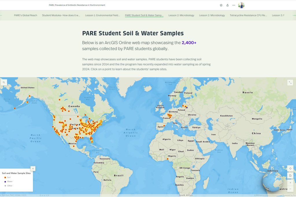
Prevalence of Antibiotic Resistance in the Environment (PARE) project at Tufts University
C Bascom-Slack, R Masilamani, C Talmadge
A Project of the Center for Science Education
View the project online: https://storymaps.arcgis.com/stories/4f20b012a5b144ee95daa8e4b54672b7
“The Prevalence of Antibiotic Resistance in the Environment (PARE) project at Tufts University is a powerful platform for student learning and scientific discovery that has potential to address the scientific challenges associated with environmental surveillance of Antibiotic Resistance (AR) and to educate tomorrow’s decision makers about the public health threat of AR and the biological concept of natural selection.”
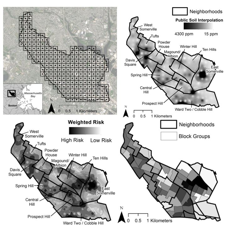
One map: Using geospatial analysis to understand lead exposure across humans, animals, and the environment in an urban US city
Tatyana J. Kalani , Adam South, Carolyn Talmadge , Jessica Leibler, Chris Whittier a, Marieke Rosenbaum
Published in Journal of One Health (2025): https://doi.org/10.1016/j.onehlt.2021.100341
Environmental lead contamination negatively impacts human, animal, and ecosystem health, yet there is a lack of research in this area that incorporates a One Health framework – examining co-exposures among species through their shared environment. The purpose of this study was to integrate human and animal data with public soil lead levels to better understand lead exposure patterns across species in an urban US city. Over 200 soil samples were collected, analyzed for lead, and mapped in combination with other risk factors pulled from the literature to identify areas of highest risk. Human socio-demographic data, dog, and house sparrow density data were mapped to investigate the association between these variables and soil lead levels. Geospatial analysis software was used to visualize the geospatial distribution of soil lead levels and known risk factors for environmental lead contamination, and a block group risk score was calculated and mapped.

Host population structure and rare dispersal events drive leptospirosis transmission patterns among Rattus norvegicus in Boston, Massachusetts, US
N. Stone, C. Hamond, J. Clegg, R. McDonough, R. Bourgeois, R. Ballard, N. Thornton, M. Nuttall, H. Hertzel, T. Anderson, R. Whealy, S. Timm, A.K. Roberts, V. Barragán, Phipatanakul, J. Leibler, H. Benson, A. Specht, R. White, K. LeCount, T. Furstenau, R. Galloway, N. Hill, J. Madison, i. Fofanov, T. Pearson, J. Sahl, J. Busch, Z. Weiner, J. Nally, D. Wagner, M. Rosenbaum
Published in bioRxiv (2024): https://www.biorxiv.org/content/10.1101/2024.06.12.598639v2
“Leptospirosis (caused by pathogenic bacteria in the genus Leptospira) is prevalent worldwide but more common in tropical and subtropical regions. The brown rat, Rattus norvegicus, is an important reservoir of leptospirosis in urban settings. We investigated leptospirosis among brown rats in Boston, Massachusetts and hypothesized that rat dispersal in this urban setting influences the movement, persistence, and diversity of Leptospira. We analyzed DNA from 328 rat kidney samples collected from 17 sites in Boston over a seven-year period (2016–2022); 59 rats representing 12 of 17 sites were positive for Leptospira.”
Public Health Research
Tufts researchers widely use GIS in health research to study exposure and risk, the role of the environment in physical activity and health, and access to healthcare.
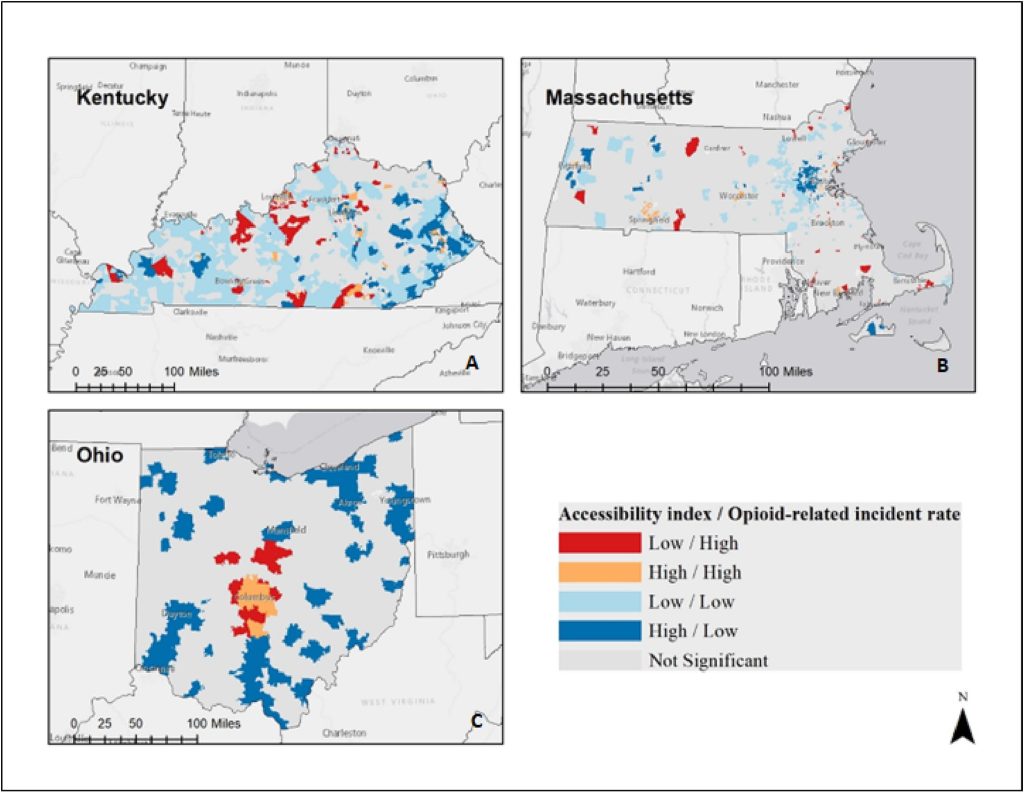
Spatial access to buprenorphine-waivered prescribers in the HEALing communities study: Enhanced 2-step floating catchment area analyses in Massachusetts, Ohio, and Kentucky
S Shrestha, MR Lindstrom, D Harris, P Rock, S Srinivasan, JC Pustz, R Bayly, TJ Stopka
Published in Journal of Substance Use and Addiction Treatment (2023): https://doi.org/10.1016/j.josat.2023.209077
“The opioid overdose epidemic continues to impact a large swath of the population in the US. Medications for opioid use disorders (MOUD) are an effective resource to combat the epidemic; however, there is limited research on MOUD treatment access that accounts for both supply of and demand for services. We aimed to examine access to buprenorphine prescribers in the HEALing Communities Study (HCS) Wave 2 communities in Massachusetts, Ohio, and Kentucky during 2021, and the association between buprenorphine access and opioid-related incidents, specifically fatal overdoses and opioid-related responses by emergency medical services (EMS).“
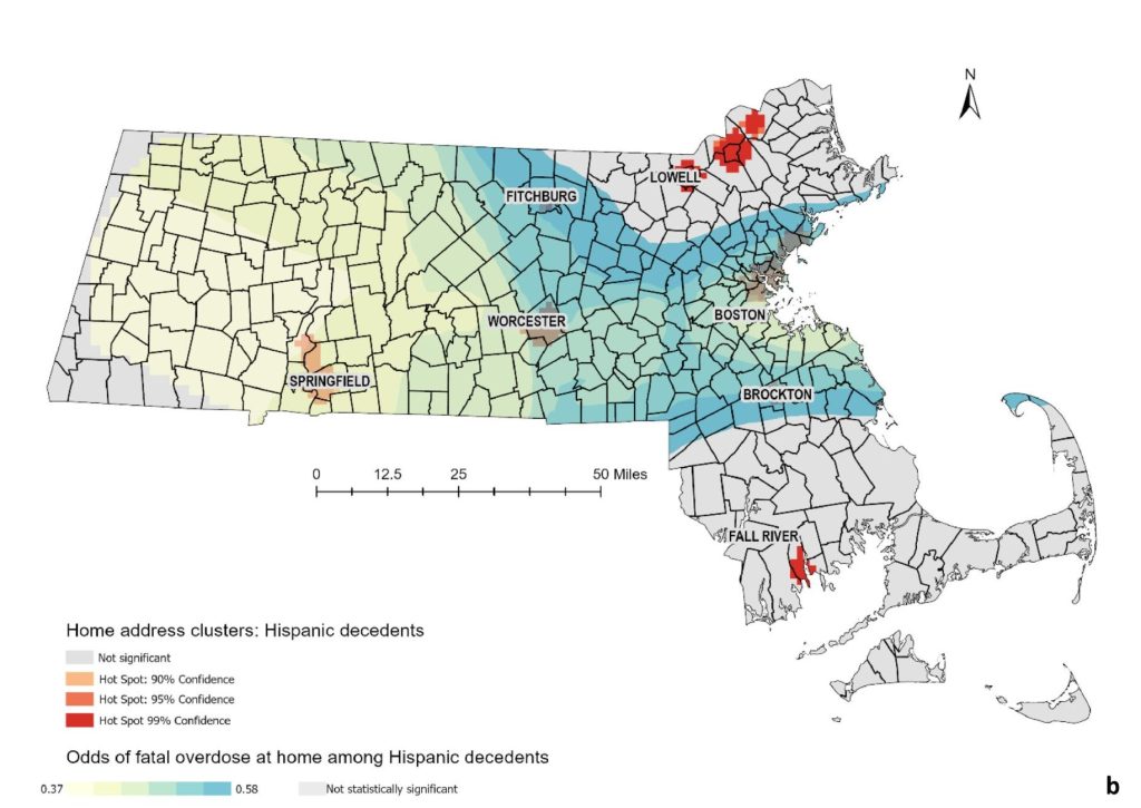
Relationships between places of residence, injury, and death: Spatial and statistical analysis of fatal opioid overdoses across Massachusetts
J Pustz, S Srinivasan, MR Larochelle, AY Walley, TJ Stopka
Published in Spatial and Spatio-temporal Epidemiology (2022): https://doi.org/10.1016/j.sste.2022.100541
“Understanding the factors associated with where people who use opioids live, where their fatal overdoses occur, and where deaths are recorded can improve our knowledge of local risk environments and inform intervention planning. Through geospatial analyses of death certificate data between 2015 and 2017, we found that a majority of opioid-involved fatal overdoses in Massachusetts occurred at home.”

Employment industry and opioid overdose risk: A pre- and post-COVID-19 comparison in Kentucky and Massachusetts 2018–2021
Sumeeta Srinivasan, Shikhar Shrestha, Daniel Harris, Olivia Lewis, Peter Rock, Anita Silwal, Jennifer Pustz, Sehun Oh, Gia Barboza-Salerno, Thomas J. Stopka
Published in Journal of Spatial and Spatio-temporal Epidemiology (2025): https://doi.org/10.1016/j.josat.2023.209077
The COVID-19 pandemic has exacerbated the risk of opioid-related harm, and previous studies suggest a connection between opioid overdose risk and industry of employment. We used descriptive and spatial-statistical tests with opioid overdose data from the vital records offices of Kentucky and Massachusetts to examine opioid overdose rates by employment industry before and after COVID-19 emergency declarations. Both states had consistently high rates of opioid-related overdose mortality for individuals employed in the construction and arts, recreation, food services, and accommodation service industries. Additionally in both states, census tracts with a high percentage of renters and non-Hispanic Black residents were more likely to be located in fatal opioid-related overdose hotspots following the initial surge of COVID-19 cases. In Kentucky, census tracts with higher percentages of employment in the transportation and other services were more likely to be located in an overdose hotspot before and after the COVID-19 emergency declaration, while in Massachusetts the same was true for census tracts with high employment in manufacturing, agriculture, forest, and fisheries, and hunting.
Risk factors for persistent fatal opioid-involved overdose clusters in Massachusetts 2011-2021: a spatial statistical analysis with socio-economic, accessibility, and prescription factors
Sumeeta Srinivasan, Jennifer Pustz, Elizabeth Marsh, Leonard D Young, Thomas J Stopka
Published in BMC Public Health (2024): https://doi.org/10.1186/s12889-024-19399-5
Fatal opioid-involved overdose rates increased from 5.0 per 100,000 population to 33.5 in Massachusetts between 1999 and 2022. We used spatial rate smoothing techniques to identify persistent opioid overdose-involved fatality clusters at the ZIP Code Tabulation Area (ZCTA) level, used Local Indicators of Spatial Association (LISA) cluster analyses with the raw incidence rates, and used Empirical Bayes smoothed rates to identify clusters from 2011 to 2021. The resulting measures were used as covariates in Conditional Autoregressive Bayesian models that acknowledge spatial autocorrelation to predict both, if a ZCTA was part of an opioid-involved cluster for fatal overdose rates, as well as the number of times that it was part of a cluster of high incidence rates. Conducting spatially robust analyses may help inform policies to identify community-level risks for opioid-involved overdose deaths sooner than depending on raw incidence rates alone. The results can help inform policy makers and planners about locations of persistent risk.
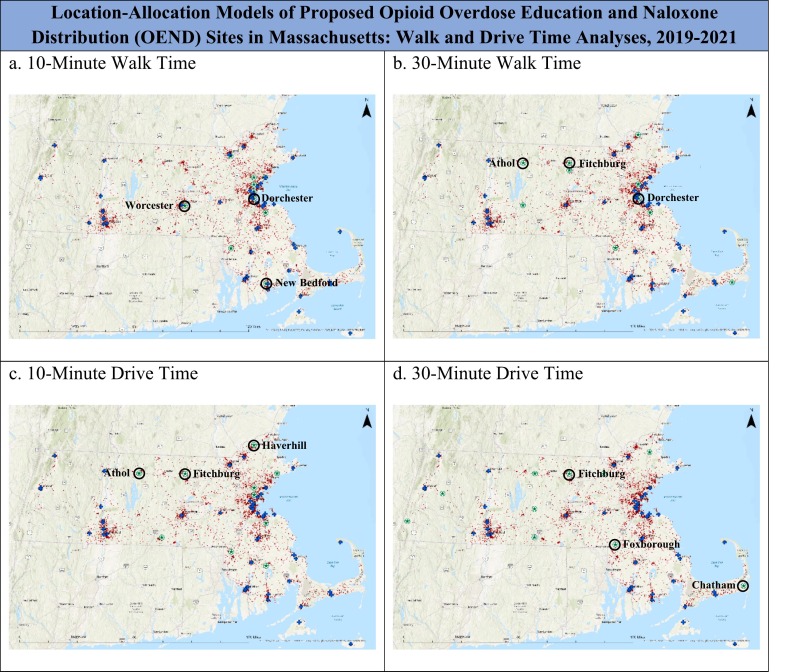
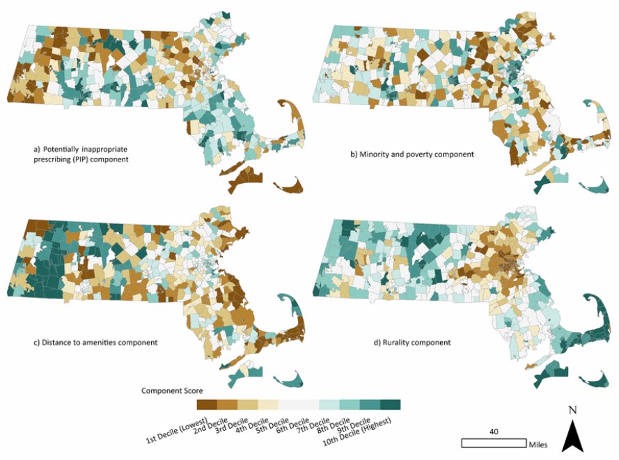
The optimization of harm reduction services in Massachusetts through the use of GIS: Location-allocation analyses, 2019-2021
Sumeeta Srinivasan, S Joshua R Parbs, Sumeeta Srinivasan, Jennifer Pustz, Ric Bayly, Shikhar Shrestha, Olivia Lewis, Simeon Kimmel, Thera Meehan, Hermik Babakhanlou-Chase, Thomas J Stopka
Published in Preventive Medicine (2024): https://doi.org/10.1016/j.ypmed.2024.108088
Fatal opioid-related overdoses (OOD) continue to be a leading cause of preventable death across the US. Opioid Overdose Education and Naloxone Distribution programs (OENDs) play a vital role in addressing morbidity and mortality associated with opioid use, but access to such services is often inequitable. We utilized a geographic information system (GIS) and spatial analytical methods to inform prioritized placement of OEND services in Massachusetts. Three Massachusetts communities were identified as priority sites for new OEND locations using location-allocation models based on capacity to maximize OOD prevention. Further models demonstrated differential access based on location and transportation. Our analyses identified key areas of Massachusetts with greatest need for OEND services. These results demonstrate the utility of using spatial epidemiological methods to inform public health recommendations.
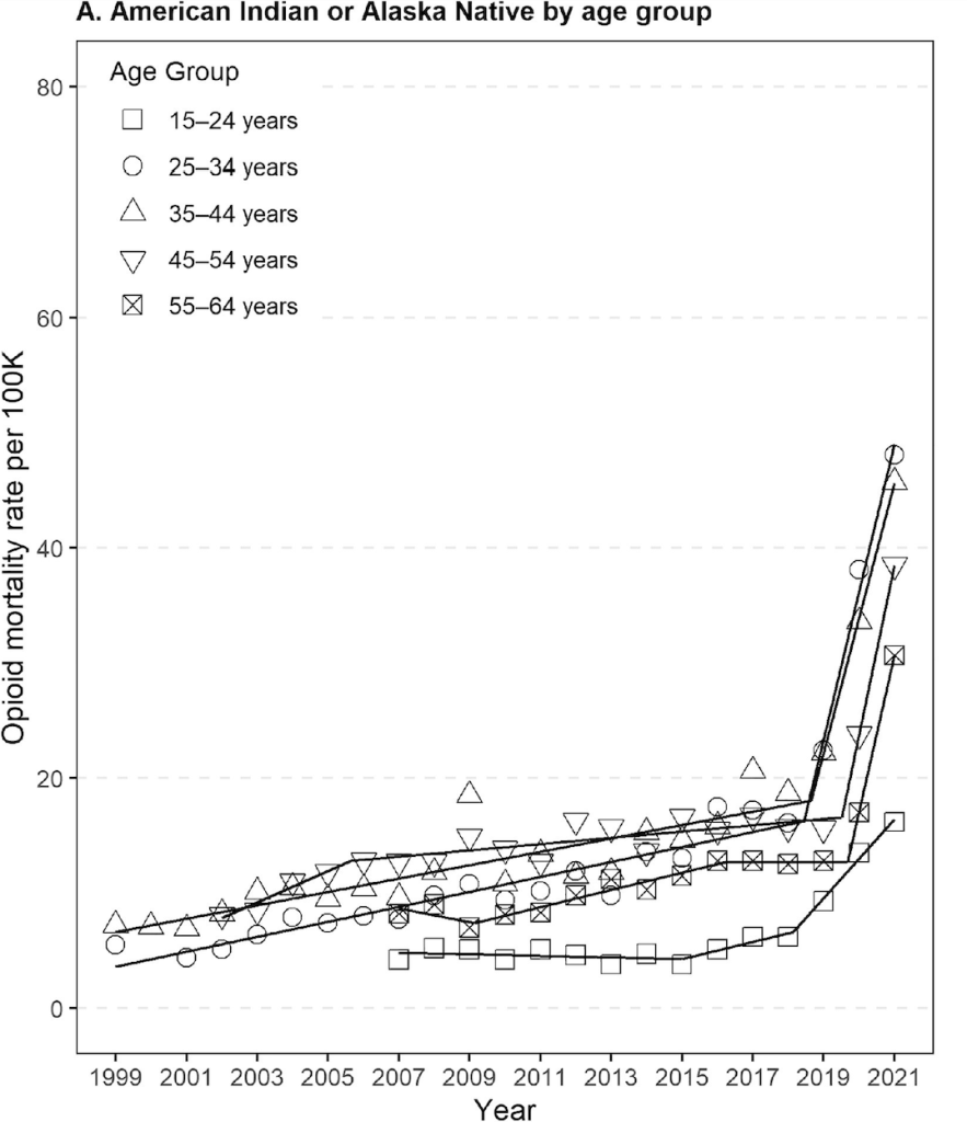
Trends in Fatal Opioid-Related Overdose in American Indian and Alaska Native Communities, 1999-2021
Cici Bauer, Ghada H Hassan, Ric Bayly, Jack Cordes, Dana Bernson, Cedric Woods, Xiaona Li, Wenjun Li, Leland K Ackerson, Marc R Larochelle, Thomas J Stopka
Published in American Journal of Preventive Medicine (2024): https://doi.org/10.1016/j.amepre.2024.01.019
Opioid-related overdose trends among American Indian and Alaska Natives require further quantification and assessment. Segmented time series analyses were conducted to estimate opioid-related overdose mortality growth rates among the American Indian and Alaska Native population between 1999 and 2021. Two distinct time segments revealed significantly different opioid-related overdose mortality growth rates within the overall American Indian and Alaska Native population. Future research should aim to understand the underlying factors contributing to these high mortality rates and employ interventions that leverage the strengths of American Indian and Alaska Native culture, including the strong sense of community.
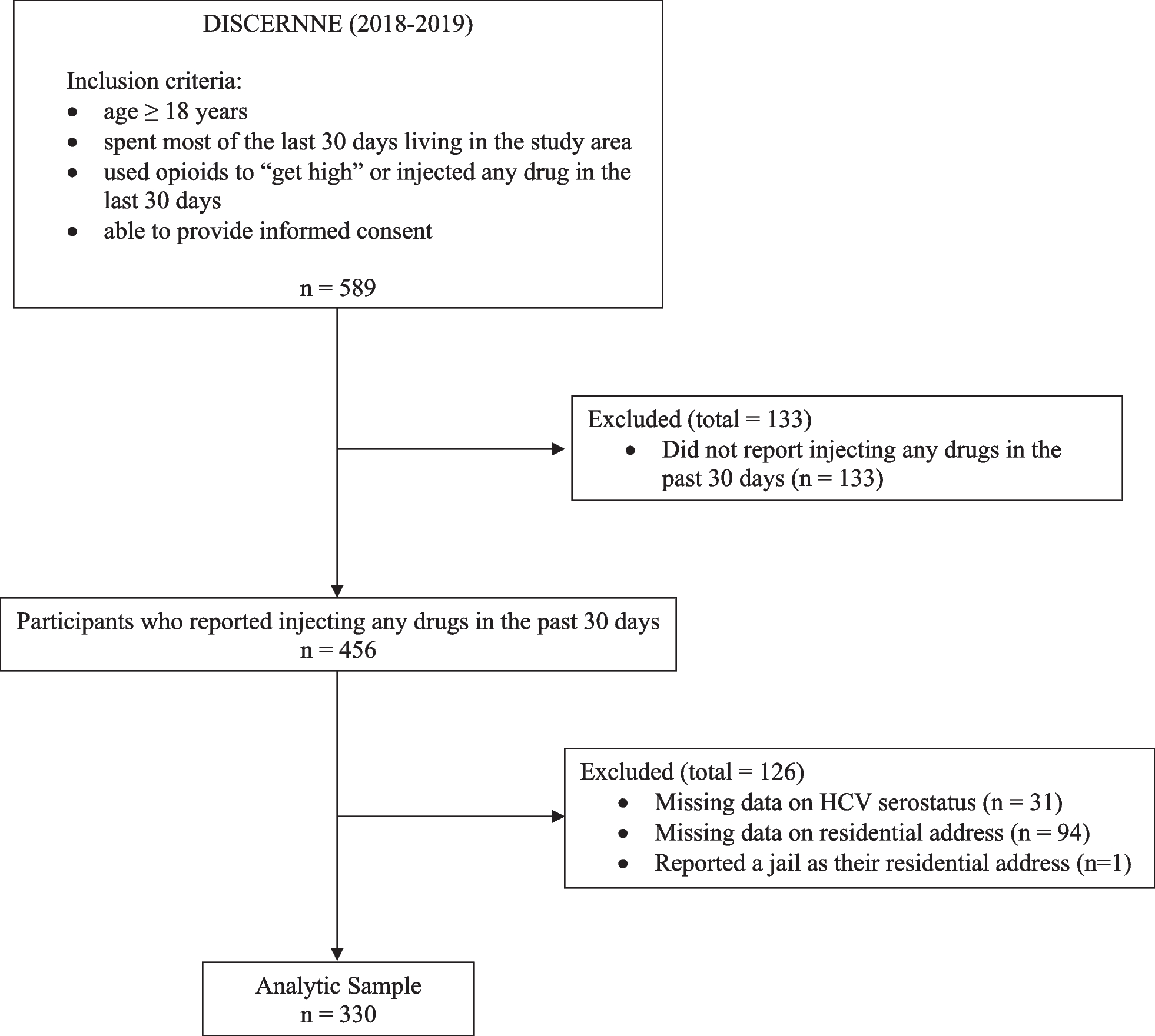
Association of spatial proximity to fixed-site syringe services programs with HCV serostatus and injection equipment sharing practices among people who inject drugs in rural New England, United States
Eric Romo, Thomas J Stopka, Bill M Jesdale, Bo Wang, Kathleen M Mazor, Peter D Friedmann
Published in Harm Reduction Journal (2024): https://doi.org/10.1186/s12954-023-00916-5
Hepatitis C virus (HCV) disproportionately affects rural communities, where health services are geographically dispersed. It remains unknown whether proximity to a syringe services program (SSP) is associated with HCV infection among rural people who inject drugs (PWID). Data are from a cross-sectional sample of adults who reported injecting drugs in the past 30 days recruited from rural counties in New Hampshire, Vermont, and Massachusetts (2018-2019). We calculated the road network distance between each participant’s address and the nearest fixed-site SSP. Staff performed HCV antibody tests and a survey assessed past 30-day injection equipment sharing practices. Mixed effects modified Poisson regression estimated prevalence ratios (aPR) and 95% confidence intervals (95% CI). Analyses were also stratified by means of transportation. Among PWID in rural New England, living farther from a fixed-site SSP was associated with a higher prevalence of HCV seropositivity, borrowing other used injection equipment, and backloading, reinforcing the need to increase SSP accessibility in rural areas. Means of transportation may modify this relationship.
Applied risk mapping and spatial analysis of address-level decedent data to inform opioid overdose interventions: The Massachusetts HEALing Communities Study
Jennifer Pustz, Sumeeta Srinivasan, Shikhar Shrestha, Marc R Larochelle, Alexander Y Walley, Jeffrey H Samet, Hermik Babakhanlou-Chase, Jane F Carpenter, Thomas J Stopka
Published in Drug and Alcohol Dependence (2023): https://doi.org/10.1016/j.drugalcdep.2023.110947
Death certificate data provide powerful and sobering records of the opioid overdose crisis. In Massachusetts, where address-level decedent data are publicly available upon request, mapping and spatial analysis of fatal overdoses can provide valuable insights to inform prevention interventions. We developed a method to clean and geocode decedent data that substituted injury locations (the likely location of fatal overdoses) for deaths recorded in hospitals. After geomasking for greater privacy protection, we created maps to visualize the spatial distribution of decedent residence addresses, alone and juxtaposed with drive and walk-time distances to opioid treatment programs (OTPs), and place of death by overdose address. We used spatial statistical analyses to identify locations with significant clusters of overdoses. By juxtaposing decedent residence data with drive- and walk-time analyses, we highlighted actionable spatial gaps in access to OTP treatment. To better understand local fatal opioid overdose risk environments and inform the development of community-level prevention interventions, we used publicly available address-level decedent data to conduct nuanced spatial analyses. Our approach can be replicated in other jurisdictions to inform overdose prevention responses.
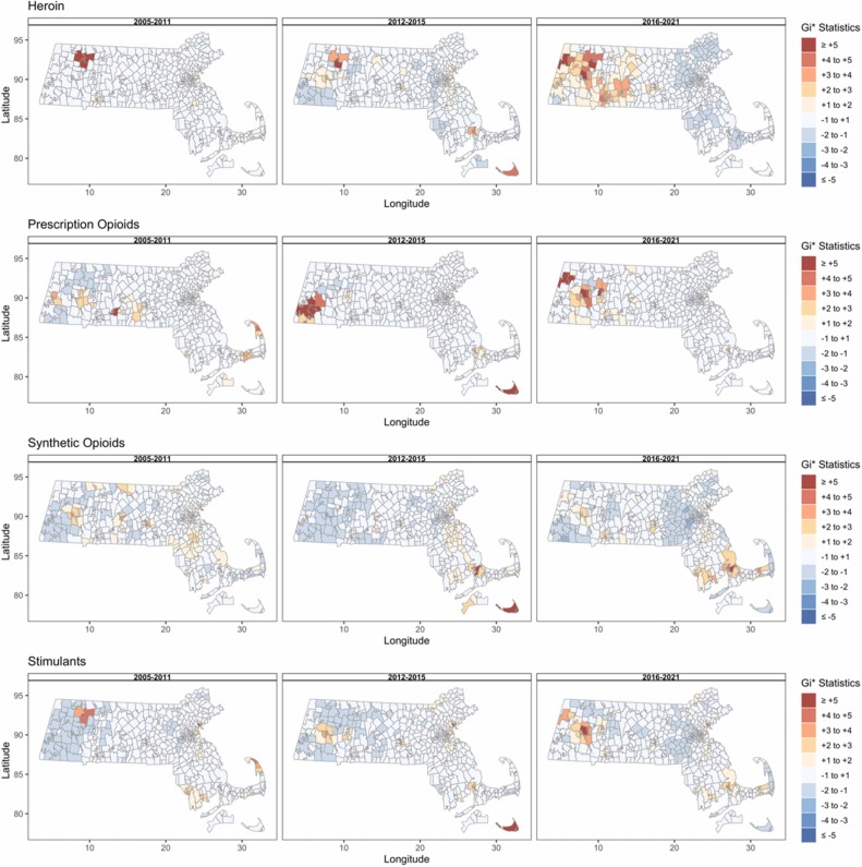
Opioid-related mortality: Dynamic temporal and spatial trends by drug type and demographic subpopulations, Massachusetts, 2005-2021
Thomas J Stopka, Marc R Larochelle, Xiaona Li, Dana Bernson, Wenjun Li, Leland K Ackerson, Ric Bayly, Olaf Dammann, Cici Bauer
Published in Drug and Alcohol Dependence (2023): https://doi.org/10.1016/j.drugalcdep.2023.109836
Fatal opioid-related overdoses (OOD) present significant public health challenges. Intuitive and replicable analytical approaches are needed to inform targeted public health responses. We obtained fatal OOD data for 2005-2021 from the Massachusetts Registry of Vital Records and Statistics and conducted heatmap analyses to assess trends in fatal OOD rates per 100,000 residents, visualizing rates by death year and decedent age at one-year intervals, stratifying by race/ethnicity, sex, rurality, and involved substances. We calculated Getis-Ord Gi* statistics to identify spatial clusters of OOD rates. Among 20,774 fatal OODs, rates were higher among males, and highly variable by race/ethnicity, age group, and rurality. Our novel approach uncovered new time varying and spatial patterns in fatal OOD rates not previously reported. Identified shifts in fatal OOD rates by sex, age, and race/ethnicity can inform location-specific field actions targeting subpopulations at disproportionally high risk.
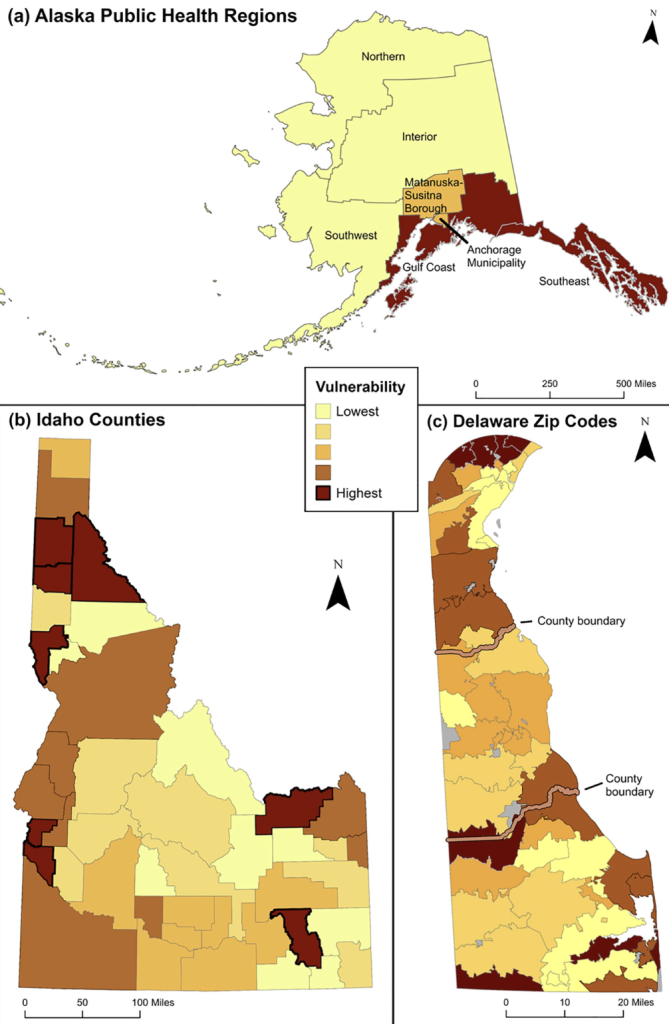
Methods for jurisdictional vulnerability assessment of opioid-related outcomes
Shikhar Shrestha, Ric Bayly, Jennifer Pustz, Jared Sawyer, Michelle Van Handel, Cailyn Lingwall, Thomas J Stopka
Published in Preventive Medicine (2023): https://doi.org/10.1016/j.ypmed.2023.107490
In 2020, an estimated 2.7 million people in the US had opioid use disorder, increasing their risk of opioid-related morbidity and mortality. While jurisdictional vulnerability assessments (JVA) of opioid-related outcomes have been conducted previously in the US, there has been no unifying methodological framework. Between 2019 and 2021, we prepared ten JVAs, in collaboration with the Council of State and Territorial Epidemiologists, the Centers for Disease Control and Prevention, and state public health agencies, to evaluate the risk for opioid-involved overdose (OOD) fatalities and related consequences. Our aim is to share the framework we developed for these ten JVAs, based on our study of the work of Van Handel et al. from 2016, as well as a summary of 18 publicly available assessments of OOD or associated hepatitis C virus infection vulnerability. We developed a three-tiered framework that can be applied by jurisdictions based on the number of units of analysis (e.g., counties, ZIP Codes, census tracts): under 10 (Tier 1), 10 to <50 (Tier 2), and 50 or more (Tier 3). We calculated OOD vulnerability indices based on variable ranks, weighted variable ranks, or multivariable regressions, respectively, for the three tiers. We developed thematic maps, conducted spatial analyses, and visualized service provider locations, drive-time service areas, and service accessibility relative to OOD risk. The methodological framework and examples of our findings from several jurisdictions can be used as a foundation for future assessments and help inform policies to mitigate the impact of the opioid overdose crisis.
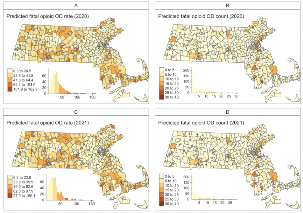
Small Area Forecasting of Opioid-Related Mortality: Bayesian Spatiotemporal Dynamic Modeling Approach
Cici Bauer, Kehe Zhang, Wenjun Li, Dana Bernson, Olaf Dammann, Marc R LaRochelle, Thomas J Stopka
Published in JMIR Public Health and Surveillance (2023): https://doi.org/10.2196/41450
Our Bayesian spatiotemporal models focused on opioid-related overdose mortality data facilitated prediction approaches that can inform preemptive public health decision-making and resource allocation. While sparse data from rural and less populated locales typically pose special challenges in small area predictions, our dynamic Bayesian models, which maximized information borrowing across geographic areas and time points, were used to provide more accurate predictions for small areas. Such approaches can be replicated in other jurisdictions and at varying temporal and geographical levels. We encourage the formation of a modeling consortium for fatal opioid-related overdose predictions, where different modeling techniques could be ensembled to inform public health policy.
Predicting Spatiotemporal Counts of Opioid-related Fatal Overdoses via Zero-Inflated Gaussian Processes
Kyle Heuton, Shikhar Shrestha,Thomas Stopka, Jennifer Pustz, Michael Hughes
Published in (2022): NeurIPS Workshop on Gaussian Processes, Spatiotemporal Modeling, and Decision-making Systems
Recently, zero-inflated Gaussian processes (GPs) have been proposed as probabilistic machine learning models for observed spatio-temporal data that contain many close-to-zero entries. In this work, we extend zero-inflated GPs to sparse count data via the zero-inflated Poisson likelihood. This change no longer admits a closed-form computation of the training objective, so we use automatic differentiation variational inference to perform approximate posterior estimation. Our motivating application is the prediction of the number of opioid-related overdose deaths that will occur in the next 3 months in each of 1620 census tracts across the state of Massachusetts, given historical decedent data and socio-economic covariates. We find zero-inflated GPs can prioritize regions in need of near-term public health interventions better than alternative models at finer spatial and temporal resolutions than most prior efforts. Surprisingly, we find that this model is successful even when using Normal likelihoods instead of the zero-inflated Poisson.
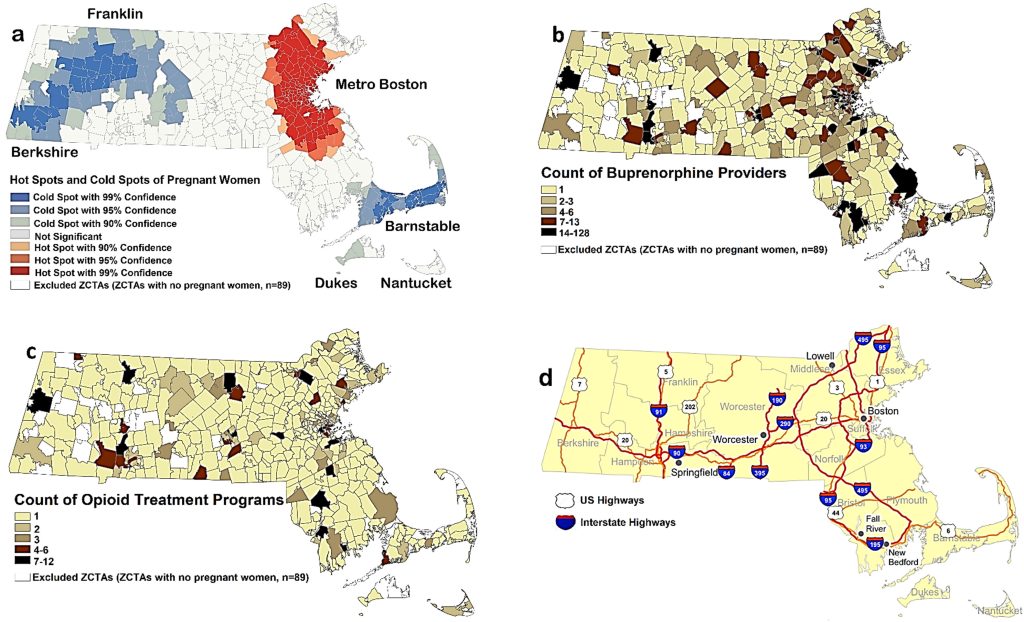
Spatial and Nonspatial Factors Associated with Access to Medication for Opioid Use Disorder among Pregnant Women in Massachusetts
Chandni Joshi, Kenneth Kwan Ho Chui, Margie R Skeer, Thomas J Stopka
Published in Substance Use & Misuse (2022): https://doi.org/10.1080/10826084.2022.2115852
This study aims to identify and characterize access to MOUD (medications for opioid use disorder) treatment among pregnant women in Massachusetts. Zip code tabulation areas with lower accessibility to both types of MOUD were concentrated in Western Massachusetts. Central Massachusetts had poor accessibility to buprenorphine providers. Accessibility was greater in ZCTAs that were nonmetropolitan, that had higher minority status and language vulnerability, and that had less extreme concentration of privilege. There is a need to improve MOUD access overall, and to enhance access to both types of medications, so pregnant women can choose the one that works best for them.
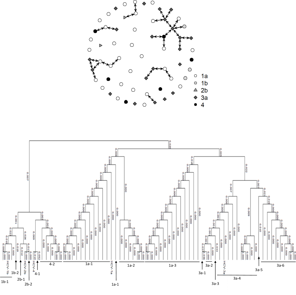
Molecular and spatial epidemiology of HCV among people who inject drugs in Boston, Massachusetts
SThomas J Stopka, Omar Yaghi, Min Li, Elijah Paintsil, Kenneth Chui, David Landy, Robert Heimer
Published in PLoS ONE (2022): https://doi.org/10.1371/journal.pone.0266216
Integration of genetic, social network, and spatial data has the potential to improve understanding of transmission dynamics in established HCV epidemics. Sequence data were analyzed from 63 viremic people who inject drugs recruited in the Boston area through chain referral or time-location sampling. HCV subtype 1a was most prevalent (57.1%), followed by subtype 3a (33.9%). The phylogenetic distances between sequences were no shorter comparing individuals within versus across networks, nor by location or time of first injection. Social and spatial networks, while interesting, may be too ephemeral to inform transmission dynamics when the date and location of infection are indeterminate.
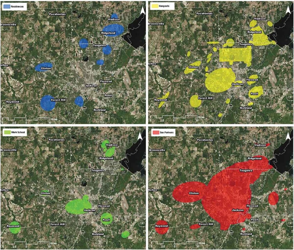
Locating the Risk: Using Participatory Mapping to Contextualize Perceived HIV Risk across Geography and Social Networks among Men Who Have Sex with Men in the Deep South
Trisha Arnold, Thomas J Stopka, Courtney E S Gomillia, Matthew Murphy, Kendra Johnson, Philip A Chan, Lynne Klasko-Foster, Brooke Rogers, Jorge H Soler, Mauda L Monger, Erin Jacque, Cassandra Sutten Coats, Tiara C Willie, Adedotun Ogunbajo, Leandro Mena, Amy Nunn
Published in Journal of Sex Research (2022): https://doi.org/10.1080/00224499.2021.1906397
HIV incidence among African American (AA) young men who have sex with men (YMSM) has remained stable even though they made up the largest number of new HIV diagnoses among men who have sex with men (MSM) in 2017. HIV spreads at increased rates in dense sexual networks. Identifying the location of risk behaviors “activity spaces” could inform geographically circumscribed HIV prevention interventions. Utilizing the modified social ecological model we completed five semi-structured focus groups incorporating a modified social mapping technique. Participants included 27 AA YMSM. Focus groups explored how and where HIV transmission happens in Jackson, Mississippi. Result themes included: 1) location of sexual behaviors, 2) knowledge of geographic hotspots of HIV infection in Jackson, and 3) traveling to meet partners: at home and away. HIV transmission or “activity spaces” may be occurring outside identified HIV hot spots. Mixed geospatial and qualitative methods offered a comprehensive assessment of where HIV transmission occurs, and suggests that geographically circumscribed interventions may need to focus on where individuals living with HIV reside and in specific geographic locations where they engage in behaviors that raise their HIV acquisition risks.
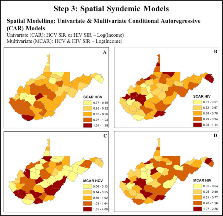
Spatial epidemiology: An empirical framework for syndemics research
Shikhar Shrestha, Cici X C Bauer, Brian Hendricks, Thomas J Stopka
Published in Social Science & Medicine (1982): https://doi.org/10.1016/j.socscimed.2020.113352
Syndemics framework describes two or more co-occurring epidemics that synergistically interact with each other and the complex structural social forces that sustain them leading to excess disease burden. In answering the call to analyze syndemics at the population level, we propose the use of spatial epidemiology as an empirical framework for syndemics research. Spatial epidemiology, which typically relies on geographic information systems (GIS) and statistics, is a discipline that studies spatial variations to understand the geographic landscape and the risk environment within which disease epidemics occur. GIS maps provide visualization aids to investigate the spatial distribution of disease outcomes, the associated social factors, and environmental exposures. Spatial and spatiotemporal models can help us to understand, measure, and analyze disease syndemics as well as the social, biological, and structural factors associated with them in space and time. In this paper, we present a background on syndemics and spatial epidemiological theory and practice. We then present a case study focused on the HIV and HCV syndemic in West Virginia to provide an example of the use of GIS and spatial analytical methods. The concepts described in this paper can be considered to enhance understanding and analysis of other syndemics for which space-time data are available.
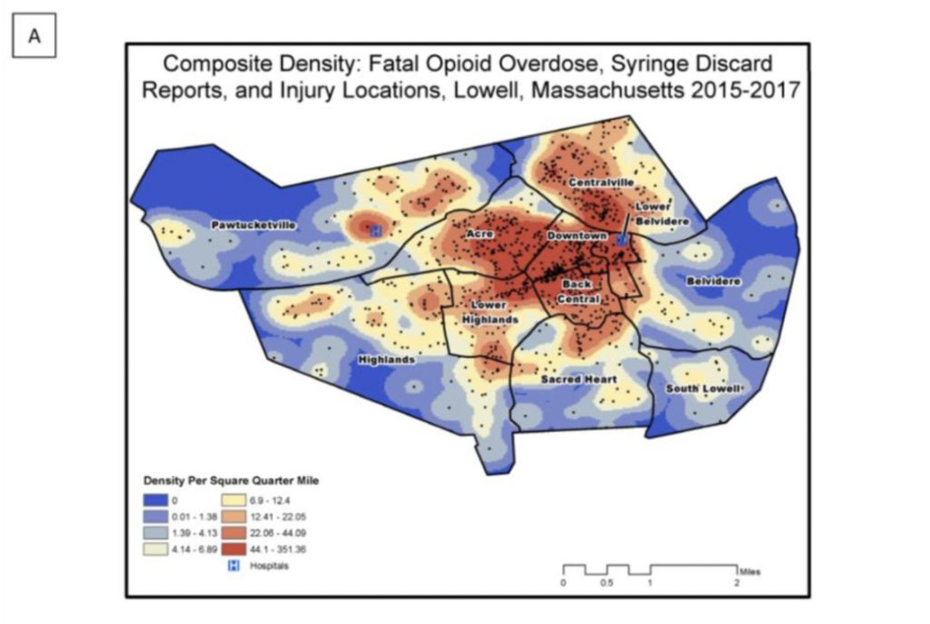
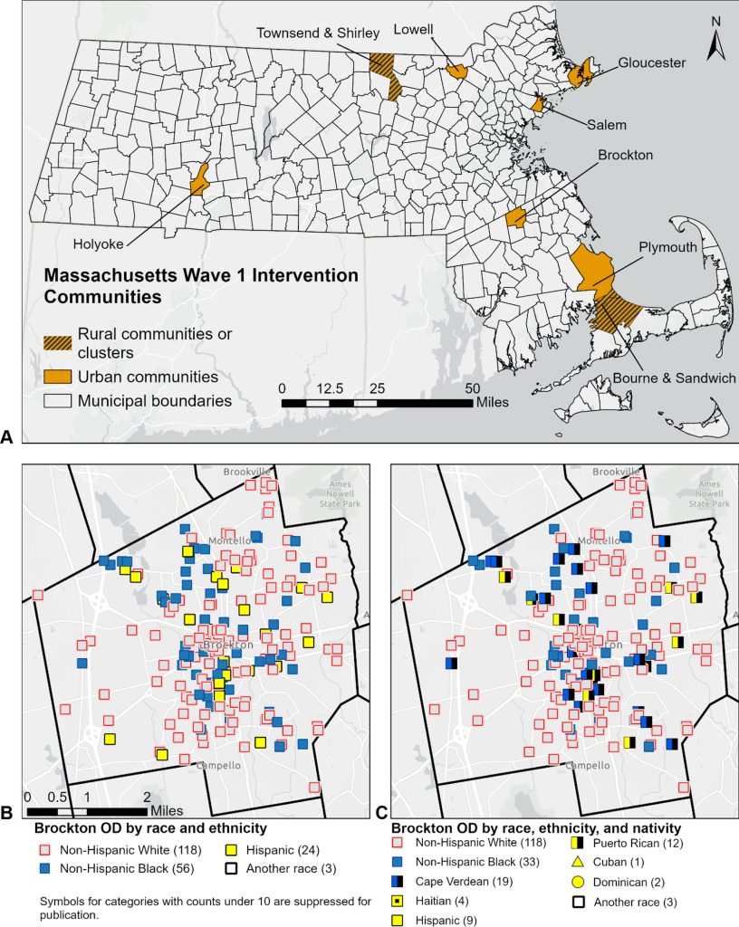
Examining the spatial risk environment tied to the opioid crisis through a unique public health, EMS, and academic research collaborative: Lowell, Massachusetts, 2008–2018
Thomas J Stopka, Erin Jacque, Jon Kelley, Lainnie Emond, Kerran Vigroux, Wilson R Palacios
Published in Preventative Medicine Reports (2021): http://10.1016/j.pmedr.2021.101591
Between 2015 and 2018, Lowell Massachusetts experienced outbreaks in opioid overdoses, HIV, and hepatitis C virus infections (HCV) among people who inject drugs. Through an innovative collaboration between emergency medical services (EMS), public health, and academic partners, we assessed the geographic distribution of opioid-related risks to inform intervention efforts. We analyzed data from three unique data sources for publicly discarded syringes, opioid-related incidents (ORIs), and fatal opioid overdoses in Lowell between 2008 and 2018. We assessed the risk environment over time using a geographic information system to identify and characterize hotspots and noted parallel trends within the syringe discard and ORI data. We also identified seasonal patterns in the syringe discard, ORI, and overdose data. Through our spatial analyses, we identified significant clusters of discarded syringes, ORIs, and fatal overdoses, and neighborhoods where high densities of these outcomes overlapped. We found that areas with the highest densities shifted over time, expanding beyond the epicenter of the Downtown neighborhood.
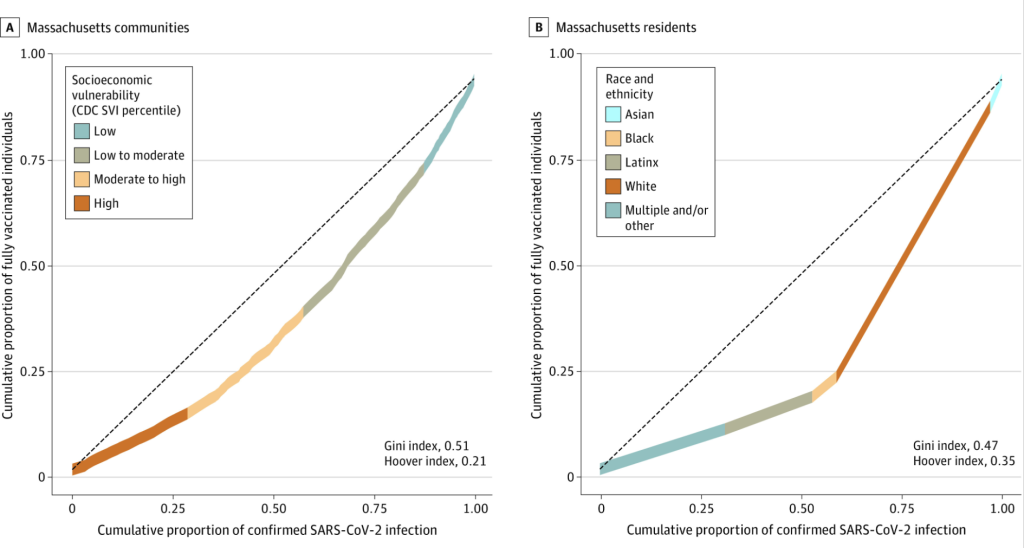
Disparities in SARS-CoV-2 Vaccination-to-Infection Risk During the COVID-19 Pandemic in Massachusetts
Scott Dryden-Peterson, Gustavo E Velásquez, Thomas J Stopka, Sonya Davey, Rajesh T Gandhi, Shahin Lockman, Bisola O Ojikutu
Published in JAMA Health Forum (2021): https://doi.org/10.1001/jamahealthforum.2021.2666
This cohort study examines the alignment of vaccination and SARS-CoV-2 risk in Massachusetts by creating and applying a vaccination-to-infection risk ratio. Analysis of SARS-CoV-2 vaccination indicated structural disparity in vaccine distribution with lower vaccine coverage to infection risk in communities with increased socioeconomic vulnerability and larger proportions of Black and Latinx individuals. In conclusion, disparities in vaccine coverage highlight ongoing inequities in the approach to COVID-19 and imperil efforts to control the pandemic.
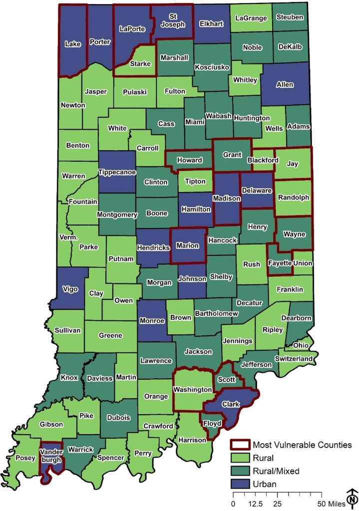
Characterizing opioid-involved overdose risk in local communities: An opioid overdose vulnerability assessment across Indiana, 2017
Jared L Sawyer, Shikhar Shrestha, Jennifer C Pustz, Robert Gottlieb, Deborah Nichols, Michelle Van Handel, Cailyn Lingwall, Thomas J Stopka
Published in Preventive Medicine Reports (2021): https://doi.org/10.1016/j.pmedr.2021.101538
The objective of this initiative was to conduct a comprehensive opioid overdose vulnerability assessment in Indiana and evaluate spatial accessibility to opioid use disorder treatment, harm reduction services, and opioid response programs. Opioid-related emergency department visit rate, opioid-related arrest rate, chronic hepatitis C virus infection rate, opioid prescription rate, unemployment rate, and percent of female-led households were independently and positively associated with opioid-involved overdose mortality. We identified high-risk counties across the rural-urban continuum and primarily in east central Indiana. We found that only one of the 19 most vulnerable counties was in the top quintile for treatment services and had naloxone provider accessibility in all of its census tracts. Findings from our vulnerability assessment provide local-level context and evidence to support and inform future public health policies and targeted interventions in Indiana in areas with high opioid overdose vulnerability and low service accessibility.
Environmental Science & Natural Resources GIS Research:
Tufts researchers are employing GIS and spatial techniques across environmental science and natural resources fields, whether identifying suitable agricultural areas, working with global climate models, identifying and classifying damage from earthquakes, studying land use change, or more.

A geospatial approach to identifying biophysically suitable areas for fruit and vegetable production in the United States
AC McCarthy, S Srinivasan, T Griffin, CJ Peters
Published in Agronomy Journal (2022): https://doi.org/10.1002/agj2.21138
“In this project, we developed geospatial models to identify and quantify land suitable for producing F&V crops across the contiguous United States based on biophysical constraints. Suitability was based on key criteria related to land cover and use, topography, soil properties, and climate. We found tremendous potential to expand F&V production at the national level, identifying 333 million hectares of suitable land, 47% of which is currently used for agriculture.“

Challenging the universality of heatwave definitions: gridded temperature discrepancies across climate regions
EC de Perez, J Arrighi, J Marunye
Published in Climatic Change (2023): https://doi.org/10.1007/s10584-023-03641-x
“As global studies of climate change depict increasingly dire outcomes of extreme heat, there is an urgent need to understand the appropriateness of heatwave defnitions and temperature datasets in diferent parts of the world. We carry out an intercomparison of the CHIRTS gridded station-satellite temperature dataset with three reanalysis products, ERA5, NCEP-DOE Reanalysis 2, and MERRA2, to assess biases in the absolute value of extreme heat events and the distribution of extreme events.”
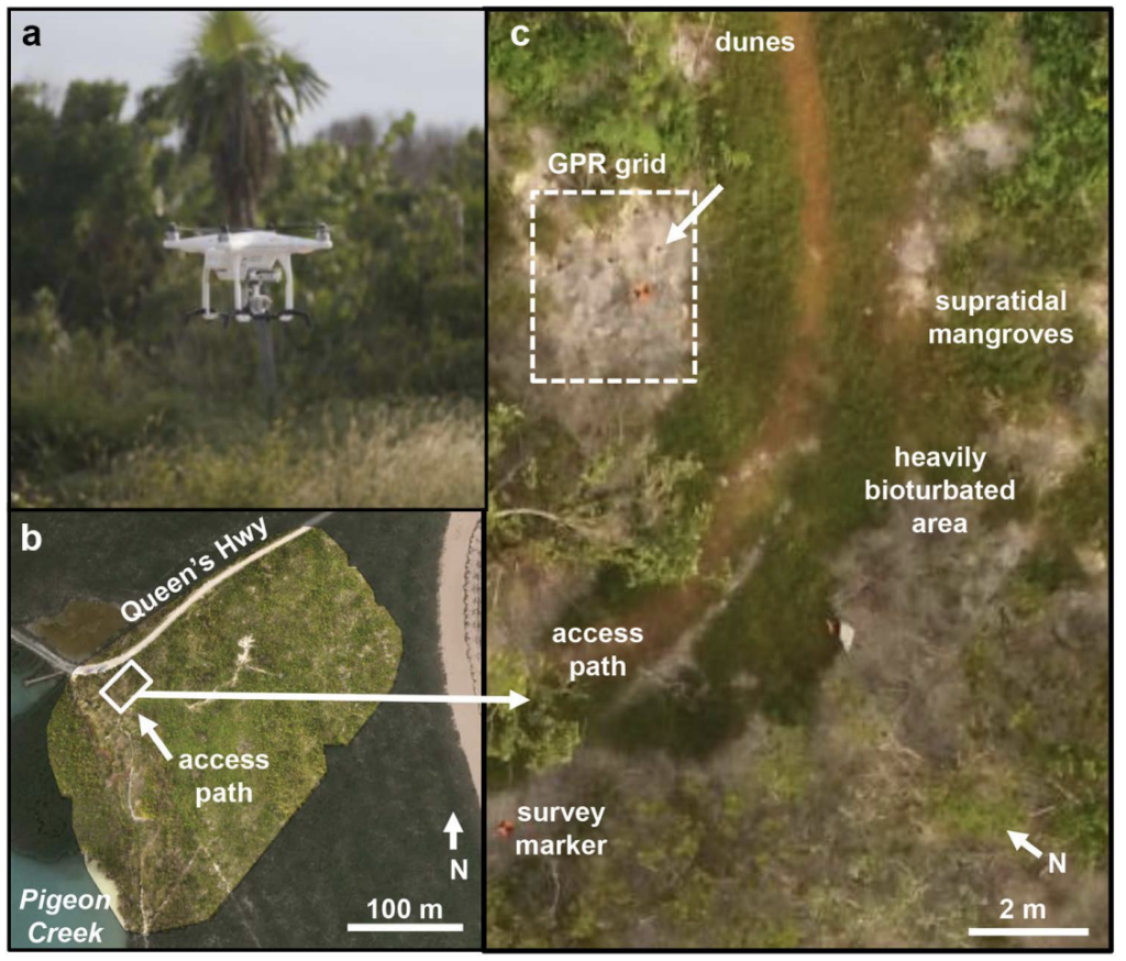
Imaging Bioturbation in Supratidal Carbonates: Non-Invasive Field Techniques Enhance Neoichnological and Zoogeomorphological Research, San Salvador, The Bahamas
K Kopcznski, I Buynevich, HA Curran, J Caris, J Nyquist
Published in Bollettino della Società Paleontologica Italiana (2017): https://scholarworks.smith.edu/geo_facpubs/51
“A case study in unconsolidated carbonates on San Salvador Island, The Bahamas, utilized high-frequency (800 MHz) georadar imaging to augment existing methodologies (burrow counts and measurements, casting) in brachyuran bioturbation research (Ocypode quadrata and Gecarcinus lateralis), and as part of a new dataset characterizing blue land crab (Cardisoma guanhumi) burrows. Non-invasive techniques such as ground-penetrating radar (GPR) can complement traditional field surveys aimed at quantifying mesoscale bioturbation in modern settings. These methods can establish diagnostic features for tracemaker identification and refine existing ichnofacies models.“
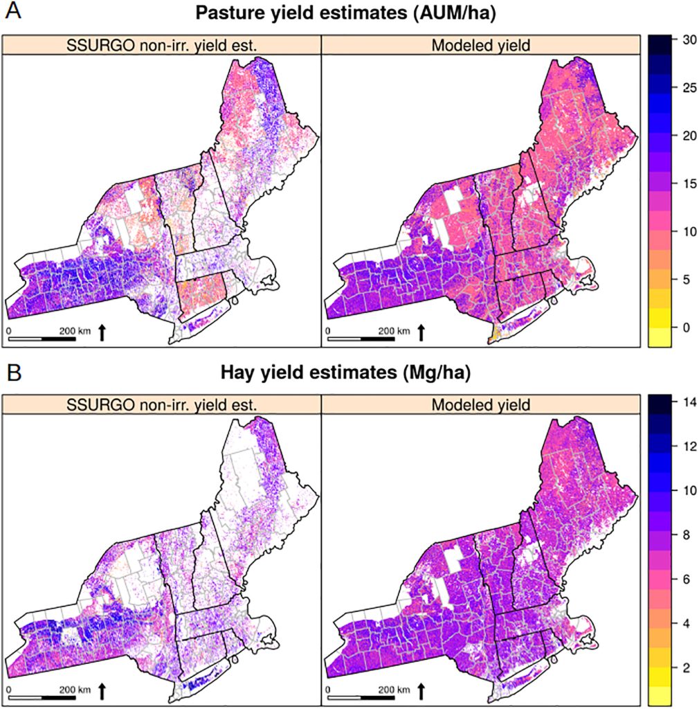
Estimating biological capacity for grass-finished ruminant meat production in New England and New York
AM Thorn, MJ Baker, CJ Peters
Published in Agricultural Systems (2021): https://doi.org/10.1016/j.agsy.2020.102958
“The Northeastern United States contributes a small share to national meat production. However, increasing interest in local food production and on-going challenges posed by drought and fire on Western rangelands give reason to believe that the importance of Northeastern grass-based ruminant meat could grow in the near future. Using an integrated modeling approach, the present study quantifies current and potential biological capacity for grass-based ruminant meat production in New York and New England”

Development of scenarios for land cover, population density, impervious cover, and conservation in New Hampshire, 2010–2100
AM Thorn, CP Wake, CD Grimm, CR Mitchell, MM Mineau, SV Ollinger
Publsihed in Ecology & Society (2017): https://doi.org/10.5751/ES-09733-220419
“Future changes in ecosystem services will depend heavily on changes in land cover and land use, which, in turn, are shaped by human activities. Given the challenges of predicting long-term changes in human behaviors and activities, scenarios provide a framework for simulating the long-term consequences of land-cover change on ecosystem function. As input for process-based models of terrestrial and aquatic ecosystem function, we developed scenarios for land cover, population density, and impervious cover for the state of New Hampshire for 2020–2100.”
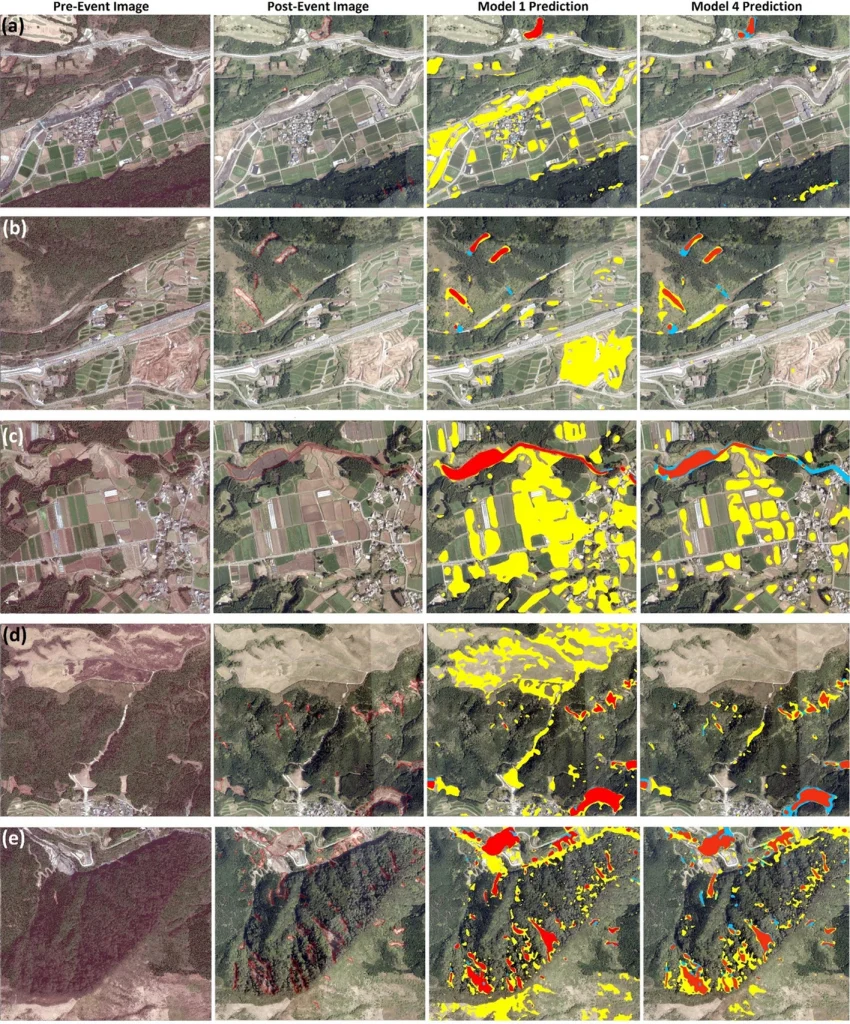
Pixel-based classification method for earthquake-induced landslide mapping using remotely sensed imagery, geospatial data and temporal change information
A Asadi, LG Baise, M Koch, B Moaveni, S Chatterjee, Y Aimaiti
Published in Natural Hazards (2024): https://doi.org/10.1007/s11069-023-06399-8
“A series of earthquakes occurred in Kumamoto, Japan, in April 2016, which caused numerous landslides. In this study, high-resolution pre-event and post-event optical imagery, plus bi-temporal Synthetic Aperture Radar (SAR) data are paired with geospatial data to train a pixel-based machine learning classification algorithm using logistic regression to identify landslides occurred because of the Kumamoto earthquakes.”
Urban Planning GIS Research:
In rapidly growing communities, local governments, planners, and citizens frequently call for policies to shape growth in a way that will reduce rates of increase in land consumption, vehicle miles traveled, energy demand, and pressure on water and air quality. Often the goals of various stakeholders within the metropolitan region will conflict. Planners use GIS as an important tool for understanding, visualizing, and quantifying current conditions and recent trends; exploring spatial relationships between transportation, land use, housing, and open space; and visualizing the metropolitan region’s future under different growth scenarios.
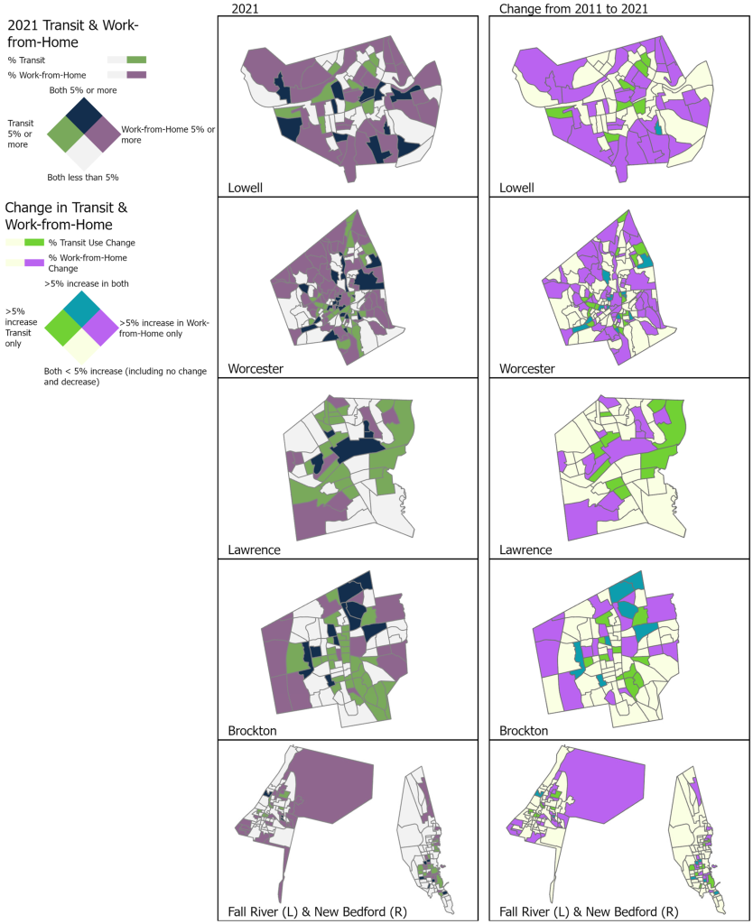
Demographic and Built Environment Predictors of Public Transportation Retention and Work-from-Home Changes in Small- to Medium-Sized Massachusetts Cities, 2011–2021
RM Shakespeare, S Srinivasan
Published in Sustainability (2024): https://doi.org/10.3390/su16198620
“Transportation uses substantial energy and is a significant household expense in the United States; public transportation and working from home present opportunities to reduce energy use and increase household affordability. However, during COVID-19, transportation systems reduced service, and nationwide, public transportation use has been declining. Focusing on six small-to-medium-sized “Gateway Cities” in Massachusetts—more affordable cities with lower-than-state-average median income and lower-than-state-average education—that have regional transit systems and are within Boston’s commuter rail area, we analyzed the changes in public transit ridership and work from home.”
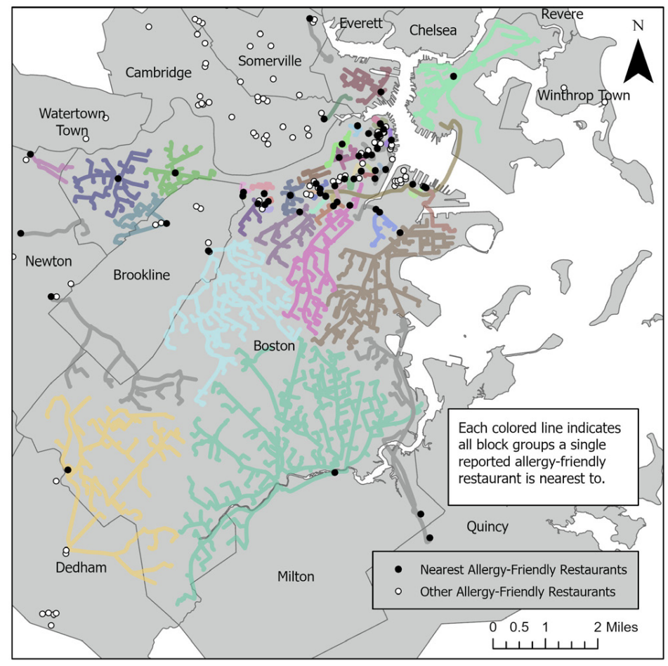
Dining Out with Allergies: Examining Boston’s Allergy-Friendly Restaurant Landscape
RM Shakespeare
Published in Gamma Theta Epsilon’s Geography Bulletin (2022): https://www.gammathetaupsilon.org/the-geographical-bulletin/2020s/volume63-1/article2.pdf
“According to a recent national survey, about ten percent of American adults, estimated 26 million, are likely to have food allergies (Gupta, et al. 2019). Food allergies have many psychosocial outcomes for adults, including social isolation, anxiety, and loneliness. Framing restaurants as a site of social engagement, this article seeks to describe the restaurant landscape for adults with food allergies in Boston. Using online user reviews from TripAdvisor and AllergyEats to identify locations of restaurants with mostly positive allergy-related reviews, this paper uses GIS to assess the geographic accessibility of allergy-friendly restaurants for locations across Boston.”

Reductions in traffic-related black carbon and ultrafine particle number concentrations in an urban neighborhood during the COVID-19 pandemic
N Hudda, MC Simon, AP Patton, JL Durant
Published in Science of the Total Environment (2020): https://doi.org/10.1016/j.scitotenv.2020.140931
“We investigated changes in traffic-related air pollutant concentrations in an urban area during the COVID-19 pandemic. The study was conducted in a mixed commercial-residential neighborhood in Somerville (MA, USA), where traffic is the dominant source of air pollution. Measurements were made between March 27 and May 14, 2020, coinciding with a dramatic reduction in traffic (71% drop in car and 46% drop in truck traffic) due to business shutdowns and a statewide stay-at-home advisory.”
A Bayesian updating framework for calibrating the hydrological parameters of road networks using taxi GPS data
X Kong, J Yang, K Xu, B Dong, S Jiang
Published in Hydrology and Earth System Sciences (2023): https://doi.org/10.5194/hess-27-3803-2023
“Hydrological parameters should pass through a careful calibration procedure before being used in a hydrological model that aids decision making. However, significant difficulty is encountered when applying existing calibration methods to regions in which runoff data are inadequate. To achieve accurate hydrological calibration for ungauged road networks, we propose a Bayesian updating framework that calibrates hydrological parameters based on taxi GPS data.”
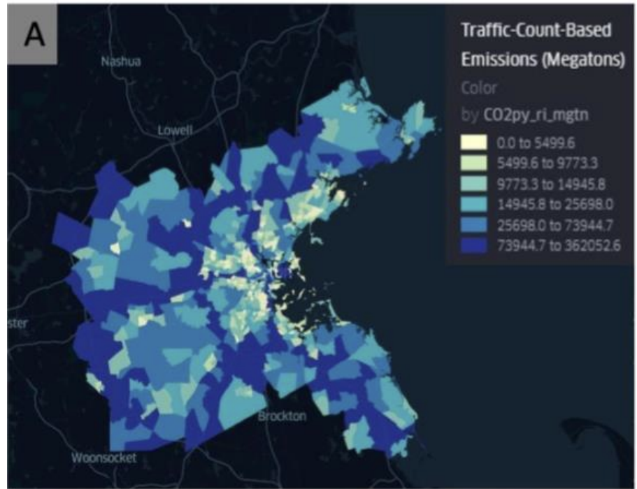
Examining Passenger Vehicle Miles Traveled and Carbon Emissions in the Boston Metropolitan Area
T Aslanyan, S Jiang
Published in Urban Informatics and Future Cities (2021): https://arxiv.org/pdf/2106.06677
“With spatial analytic, econometric, and visualization tools, this book chapter investigates greenhouse gas emissions for the on road passenger vehicle transport sector in the Boston metropolitan area in 2014. It compares greenhouse gas emission estimations from both the production-based and consumption based perspectives with two large-scale administrative datasets the vehicle odometer readings (from individual vehicle annual inspection) and the road inventory data (containing roadsegment level geospatial and traffic information).
International Relations GIS Research:
Tufts researchers are at the forefront of humanitarian assistance and international development work and apply GIS to these important fields. Whether helping tell the stories of migrants, thinking about sustainable global economies, exploring international agriculture and food systems, or thinking about affordability, these researchers are pushing the boundaries of GIS work.
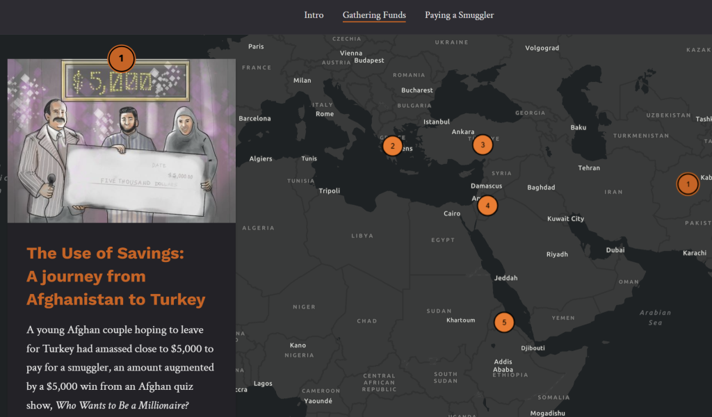
The Displacement Series
K Wilson, K Jacobsen
A project of the Henry J. Leir Institute for Migration and Human Security at the Fletcher School of Law and Diplomacy
Published online (2021): View the StoryMap
“Part of The Journey’s Project: a multimedia storytelling project examining the costs of survival for refugees as they traverse the planet and re-identify home.”
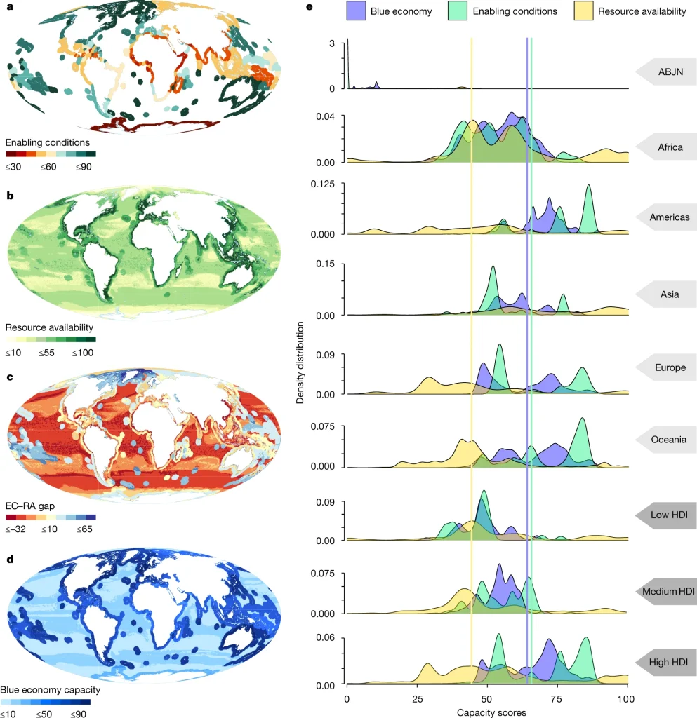
Enabling conditions for an equitable and
sustainable blue economy
AM Cisneros-Montemayor, M Moreno-Baez, G Reygondeau, …, Y Ota
Published in Nature (2021): http://doi.org/10.1038/s41586-021-03327-3
“The future of the global ocean economy is currently envisioned as advancing towards a ‘blue economy’—socially equitable, environmentally sustainable and economically viable ocean industries. However, tensions exist within sustainable development approaches, arising from differing perspectives framed around natural capital or social equity. Here we show that there are stark differences in outlook on the capacity for establishing a blue economy, and on its potential outcomes, when social conditions and governance capacity—not just resource availability—are considered, and we highlight limits to establishing multiple overlapping industries.”
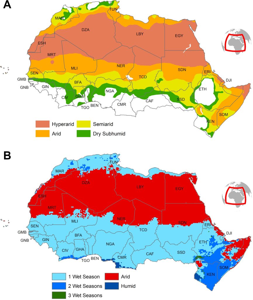
Seasonality of Acute Malnutrition in African Drylands: Evidence From 15 Years of SMART Surveys
A Venkat, A Marshak, H Young, EN Naumova
Published in Food and Nutrition Bulletin (2023): https://doi.org/10.1177/03795721231178344
“Reduction of wasting, or low weight-for-height, is a critical target for the Zero Hunger Sustainable Development Goal, yet robust evidence establishing continuous seasonal patterns of wasting is presently lacking. The current consensus of greatest hunger during the preharvest period is based on survey designs and analytical methods, which discretize time frame into preharvest/postharvest, dry/wet, or lean/plenty seasons. We present a spatiotemporally nuanced study of acute malnutrition seasonality in African drylands using a 15-year data set of Standardized Monitoring and Assessment of Relief and Transition surveys (n = 412,370). Climatological similarity was ensured by selecting subnational survey regions with 1 rainy season and by spatially matching each survey to aridity and livelihood zones.”

Cost and affordability of healthy diets across and within countries
A Herforth, Y Bai, A Venkat, K Mahrt, A Ebel, WA Masters
Published by the FAO online (2020): https://www.fao.org/agrifood-economics/publications/detail/en/c/1364162/
“Price and affordability are key barriers to accessing sufficient, safe, nutritious food to meet dietary needs and food preferences for an active and healthy life. In this study, the least-cost items available in local markets are identified to estimate the cost of three diet types: energy sufficient, nutrient adequate, and healthy (meeting food-based dietary guidelines). For price and availability the World Bank’s International Comparison Program (ICP) dataset is used, which provides food prices in local currency units (LCU) for 680 foods and non-alcoholic beverages in 170 countries in 2017. In addition, country case studies are developed with national food price datasets in United Republic of Tanzania, Malawi, Ethiopia, Ghana and Myanmar.”
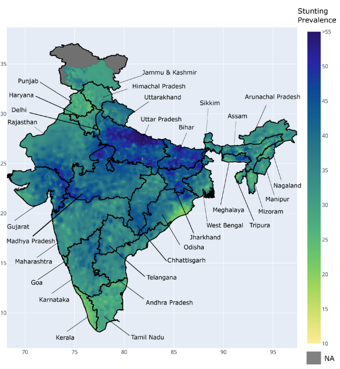
Modeling the potential impacts of improved monthly income on child stunting in India: a subnational geospatial perspective
S Kishore, T Thomas, H Sachdev, AV Kurpad, P Webb
Published in BMJ Open (2022): doi.org/10.1136/bmjopen-2021-055098
“Approximately one-third of the world’s stunted (low height-for-age) preschool-aged children live in India. The success of interventions designed to tackle stunting appears to vary by location and depth of poverty. We developed small-area estimation models to assess the potential impact of increments in household income on stunting across the country. Two nationally representative cross-sectional datasets were used: India’s National Family Health Survey 4 (2015–2016) and the 68th round of the National Sample Survey on consumer expenditure. The two datasets were combined with statistical matching. Gaussian process regressions were used to perform geospatial modelling of ‘stunting’ controlling for household wealth and other covariates.”
Digital Humanities Research and Projects:
Tufts is a leader in the growing geospatial humanities field helping bring alive the stories of the marginalized and investigating questions of equity.
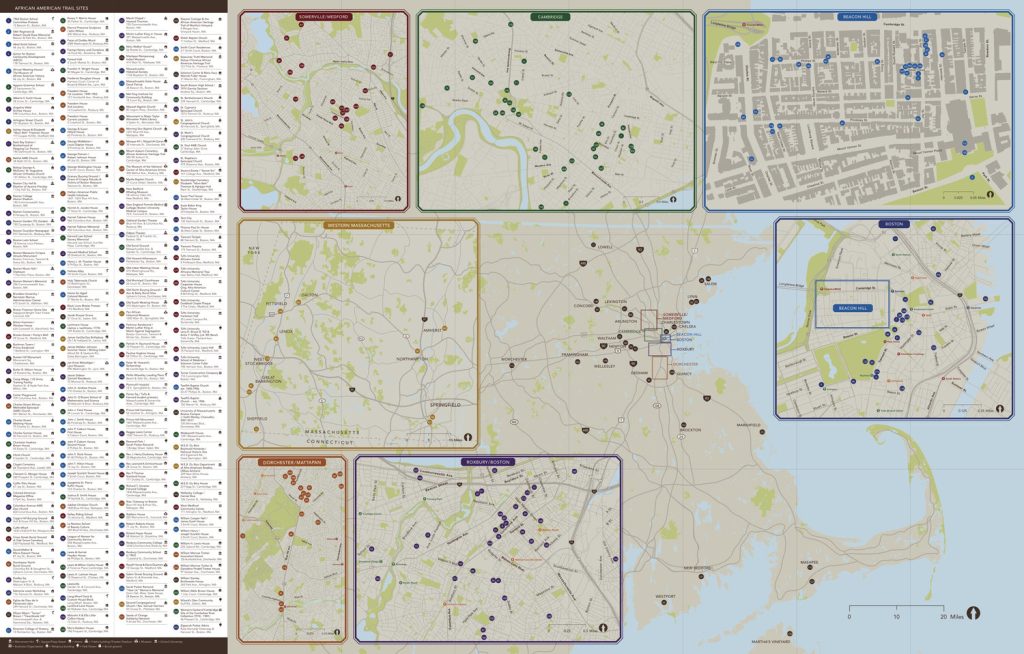
African American Trail Project
K Field, K Greenidge
A project of the Center for the Study of Race and Democracy at Tufts University
Published online (2023): https://africanamericantrailproject.tufts.edu/
“The African American Trail Project is a collaborative public history initiative housed at Tufts University. Originally inspired by the scholarship of Tufts Professor Gerald R. Gill (1948-2007) and driven by faculty and student research, this project maps African American and African-descended public history sites across greater Boston, and throughout Massachusetts. The African American Trail Project aims to develop African American historical memory and intergenerational community, placing present-day struggles for racial justice in the context of greater Boston’s historic African American, Black Native, and diasporic communities.”

Police redistricting reforms and urban governance
D Gordon, A Davis-Pait
Published in Law & Policy (2022): https://doi.org/10.1111/lapo.12196
“Police redistricting reforms are surprisingly understudied. While many understand redistricting in other realms as a mechanism of social inclusion and exclusion, police redistricting is often overlooked as merely technocratic. We argue that, in fact, police redistricting reforms are substantively and theoretically important because they articulate urban policy amid the pressures of neoliberal governance. Redistricting defines the functions and activities of the police, responds to political and economic pressures, and redistributes resources across racial spaces. To illustrate, we analyze publicly available materials describing 43 police redistricting reforms in 35 major cities in the United States. We find in these reforms an enduring emphasis on the role of the police as emergency service providers. Urban austerity and growth politics inflect redistricting and impact the distribution of police service across the city. While redistricting can theoretically result in more equitable policing, it can also amplify racial inequities by triaging resources toward downtowns and predominantly white neighborhoods, at the expense of police response in communities of color.”
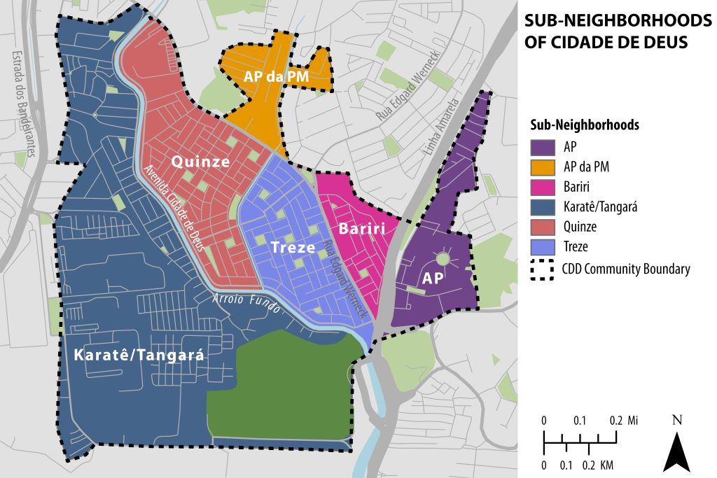
Activism under Fire: The Politics of Non-Violence in Rio de Janeiro’s Gang Territories
A book by Anjuli Fahlberg
Assistant Professor, Department of Sociology
Published by Oxford University Press (2023): https://doi.org/10.1093/oso/9780197519325.001.0001
“Rio de Janeiro’s favelas have become among the most well-known of Latin America’s neighborhoods under siege by armed drug gangs and invading militarized police. Since the 1970s, dangerous networks between drug traffickers and corrupt state actors have transformed these poor neighborhoods into sites of armed conflict and political repression, limiting residents’ ability to speak out against violence or demand their democratic rights. Despite these challenges, non-violent politics remains an integral element in Cidade de Deus, one of Rio’s most dangerous and famous favelas. Activism under Fire examines how local activists have adapted their mobilization efforts to this context, protesting against violence, making demands for their rights, and improving the neighborhood without directly endangering their lives.”
The Metric Geometry and Gerrymandering Group (MGGG) Redistricting Lab
PI: Moon Duchin
Visit the lab website: https://mggg.org/
“The MGGG Redistricting Lab is a research group at the Brooks School of Public Policy at Cornell University, led by PI Moon Duchin, that grew out of an informal research collective called the Metric Geometry and Gerrymandering Group. From 2018-2024, the Lab was based in the Tisch College of Civic Life at Tufts University, where we maintain an affiliation. Together with our close collaborators, we have expertise and interests spanning mathematics (geometry, topology, discrete math, dynamics), algorithms, software development, geography, science studies, law, and policy. We research data science interventions – better mechanisms, better models, better metrics – for democracy.”
Engineering GIS Research:
Tufts engineers are using GIS to prototype new sensors for air pollution, investigate green energy solutions, think about flood modeling, and more.
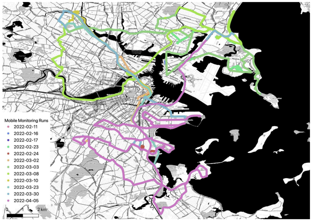
Evaluating the Performance of Low-Cost PM2.5 Sensors in Mobile Settings
P deSouza, A Wang, Y Machida, T Duhl, S Mora, P Kumar, R Kahn, C Ratti, JL Durant, N Hudda
Published in Environmntal Science & Technology (2023): https://doi.org/10.1021/acs.est.3c04843
“Low-cost sensors (LCSs) for measuring air pollution areincreasingly being deployed in mobile applications, but questions concerningthe quality of the measurements remain unanswered. For example, what is thebest way to correct LCS data in a mobile setting? Which factors mostsignificantly contribute to differences between mobile LCS data and those ofhigher-quality instruments? Can data from LCSs be used to identify hotspotsand generate generalizable pollutant concentration maps? To help address thesequestions, we deployed low-cost PM2.5 sensors (Alphasense OPC-N3) and aresearch-grade instrument (TSI DustTrak) in a mobile laboratory in Boston, MA, USA.

Hurricane risk assessment of offshore wind turbines
ST Hallowell, AT Myers, SR Arwade, W Pang, P Rawal, EM Hines, …, CM Fontana
Published in Renewable Energy (2018): https://doi.org/10.1016/j.renene.2018.02.090
“A barrier to the development of the offshore wind resource along the U.S. Atlantic coast is a lack of quantitative measures of the risk to offshore wind turbines (OWTs) from hurricanes. The research presented in this paper quantifies the risk of failure of OWTs to hurricane-induced wind and waves by developing and implementing a risk assessment framework that is adapted from a well-established framework in performance-based earthquake engineering. Both frameworks involve the convolution of hazard intensity measures (IMs) with engineering demand parameters (EDPs) and damage measures (DMs) to estimate probabilities of damage or failure. The adapted framework in this study is implemented and applied to a hypothetical scenario wherein portions of nine existing Wind Farm Areas (WFAs), spanning the U.S. Atlantic coast, are populated with ∼7000 5 MW OWTs supported by monopiles.”
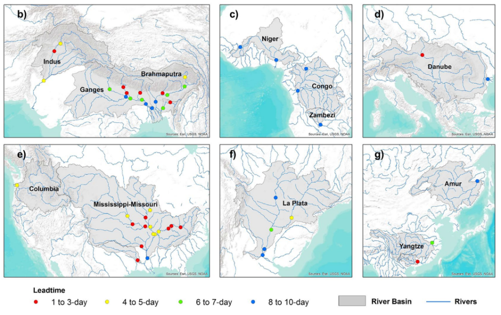
A data-driven global flood forecasting system for medium to large rivers
W Palash, AS Akanda, S Islam
Published in Scientific Reports (2024): https://doi.org/10.1038/s41598-024-59145-w
“Losses from catastrophic foods are driving intense eforts to increase Losses from catastrophic floods are driving intense efforts to increase preparedness and improve response to disastrous flood events by providing early warnings. Yet accurate flood forecasting remains a challenge due to uncertainty in modeling, calibrating, and validating a useful early warning system. This paper presents the Requisitely Simple (ReqSim) flood forecasting system that includes key variables and processes of basin hydrology and atmospheric forcing in a data-driven modeling framework.”