The Esri ArcGIS Platform has many popular software packages and web-based applications available to Tufts University students, faculty, and staff through our Tufts Organizational Account for your mapping, spatial analysis, database management, field data survey collection, and storytelling needs.

Resources and FAQs:
- Resources for Installing or Accessing ArcGIS Pro
- How do I install ArcGIS Desktop (ArcGIS Pro) Products?
- How do I sign into ESRI ArcGIS Pro?
- Can I access ArcGIS Pro remotely without installing it?
- Where is the software installed on campus?
- Where can the software be installed?
- How can I connect to the H, M, or S GIS Network Drives?
- How do I choose the right computer for ArcGIS Desktop?
- Overview of ESRI Applications and Software
- ArcGIS Pro Overview
- ArcGIS Online Overview
- ArcGIS Field Maps
- Survey123 for ArcGIS
- ArcGIS StoryMaps
- ArcGIS Dashboards
- ArcGIS Business Analyst
- ArcGIS Community Analyst
- ArcGIS Urban
- ESRI Living Atlas
Installing or Accessing ArcGIS Pro
NOTE: As of June 2025, ArcMap is no longer supported by ESRI or available at Tufts. This is a change to ESRI’s software. The primary desktop ESRI application is officially ArcGIS Pro.
ArcGIS Pro is the primary desktop GIS application. It can only be installed on a Windows Operating System. Tufts Technology Services holds a university-wide site license for ESRI products. The software may only be used for educational, research, and academic purposes, and not for commercial use or resale.
How do I install ArcGIS Pro ?
Note: ArcGIS Pro are only available to install on Window PCs. If you are a Mac User, you *can* install it using VMware fusion, Parallels, or Bootcamp and then installing Windows. However, it is not for the faint of heart and Tufts Data Lab and TTS do not support this install.
How to Install ArcGIS Pro on your Windows Computer
This guide include information on how to install ArcGIS Pro on your Windows OS
Can I access ArcGIS Pro remotely without installing it?
Yes! Tufts students, faculty, or staff can access ArcGIS Pro remotely through the Tufts Engineering Lab (VDI). They are not available on the TTS Virtual Lab (VDI). Click here for more information on Tufts VDIs.
Where is the software installed on campus?
ArcGIS Pro is installed in most Tufts Computer labs across all four campuses, including Tisch Data Lab, EPDC, Anderson 318, JCC computer labs, Mugar (Ginn) Computer Lab, Braker Computer Lab, Tisch Library computers, HHSL Data Lab and classrooms (MedEd 514 and 510), Webster Library laptops, and SMFA computer labs.
If you would like to request that ArcGIS Pro be installed in a computer lab that is not listed, please reach out to Carolyn Talmadge at DataLab-Support@elist.tufts.edu.
Where can the software be installed?
ArcGIS Pro can be installed by Tufts students, faculty, or staff on any Tufts-owned or personal computer running Windows OS. It can also be installed in any Windows Tufts’ computer labs (see above).
If you are using a Tufts Owned Computer and are not an administrator of that computer, you will need to contact TTS for help installing the software. You can email IT@tufts.edu to request assistance installing ArcGIS on a tufts owned computer.
If you have questions about installing the software or licenses, please reach out to Carolyn Talmadge at DataLab-Support@elist.tufts.edu.
How can I connect to the H, M, or S GIS Network Drives?
Instructions for accessing the three GIS network drives can be found here: GIS Network Drives page.
How do I choose the right computer for ArcGIS Desktop?
How to Choose the right computer for ArcGIS Desktop Tip Sheet – This tip sheet provides information on processors, RAM, hard drive, and resolution suggestions for the best ArcGIS experience.
Tufts University ESRI ArcGIS License
How do I sign into ESRI ArcGIS applications and software using Tufts organizational account?
In order to log into ANY ESRI application, including ArcGIS Pro and ESRI ArcGIS online web-based tools and applications, users must log in using our Tufts University Organizational Account.
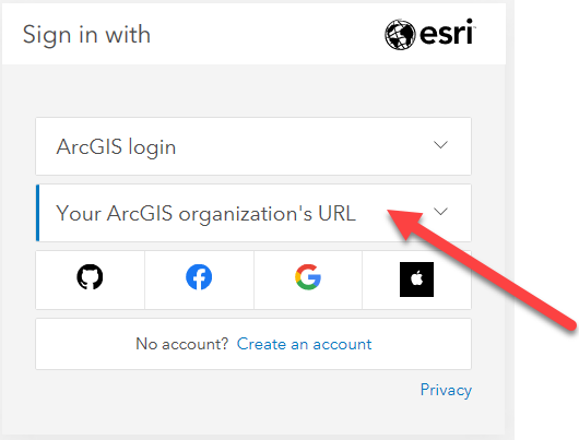
1) In either ArcGIS Pro or an ESRI online application (i.e https://www.arcgis.com/ ; https://storymaps.arcgis.com/ ; https://survey123.arcgis.com/, etc), click on the Sign In box usually at the top right of the page.
2) Click on Sign in with Your ArcGIS organization’s URL. Do NOT click sign in with ArcGIS Login
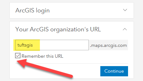
3) Enter tuftsgis as the organizations URL so it looks like the following image.
If this is your personal computer, you can check remember this URL and it will be faster next time.
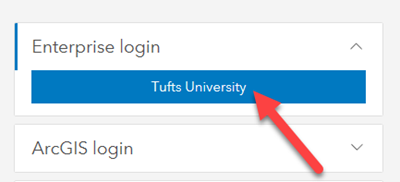
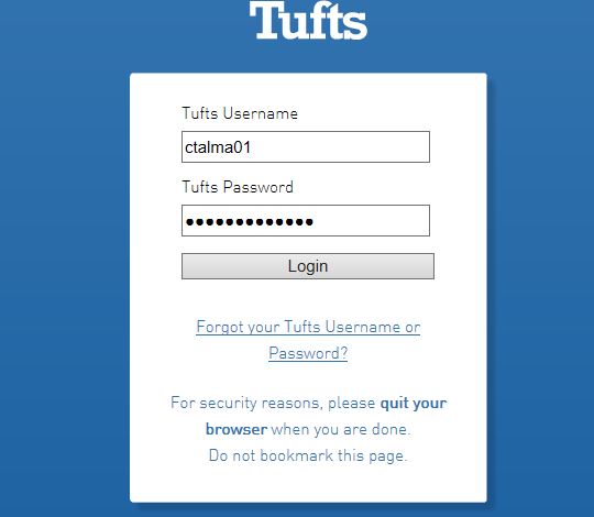
4) You will then be prompted to log in with TUFTS UNIVERSITY. Press the blue Tufts button. Then log in with your Tufts UTLN and password. Press Login.
You will need to also go through duo authentication.
What Applications and Extensions are included in Tufts University’s License?
The following ESRI Applications are available to Tufts University students, faculty, and staff:
- ArcGIS Pro Advanced Extensions – These are extensions within ArcGIS Pro Desktop and are enabled by default for users who are logged into our organizational account.
- 3D Analyst.
- Aviation Airports
- Aviation Charting
- Bathymetry
- Business Analyst
- Data Interoperability
- Data Reviewer
- Defense Mapping
- Geostatistical Analyst
- Image Analyst
- Locate XT
- Network Analyst
- Production Mapping
- Publisher
- Spatial Analyst
- Workflow Manager
- **StreetMap Premium North America – NOTE – This extension is NOT enabled by default. User’s must request access by emailing DataLab-Support@elist.tufts.edu and requesting their license be enabled.
- Compatible Add-on Licenses – Tufts has enabled these licenses by default.
- ArcGIS Urban Suite
- ArcGIS Drone2Map Advanced – *Installed as a separate application
- ArcGIS Drone2Map Standard
- Esri Redistricting
- ArcGIS Business Analyst Web and Mobile Apps Advanced
- ArcGIS Community Analyst – *This application is being retired by ESRI as of October 2024. Any existing content will be transferred to Business Analyst.
- ArcGIS Insights
- ArcGIS GeoPlanner
- Compatible Add-on Licenses – These licenses are NOT automatically enabled. User’s must request access by emailing DataLab-Support@elist.tufts.edu and requesting their license be enabled.
- ArcGIS Location Sharing
- ArcGIS Image for ArcGIS Online
- Web Based “Essential Apps” Included in the License
- ArcGIS Online – Main entry point for all things ESRI ArcGIS!
- ArcGIS AppStudio
- ArcGIS Dashboards
- ArcGIS Data Pipelines
- ArcGIS Experience Builder
- ArcGIS Hub Basics
- ArcGIS Instant Apps
- ArcGIS QuickCapture Web Designer
- ArcGIS StoryMaps
- Survey123 for ArcGIS Online
- ArcGIS WebApp Builder
- Configurable Apps
- Map Viewer (and Map Viewer Classic)
- Scene Viewer
- ArcGIS GeoBIM
- Field Apps included in the License
- App Bundles – Requires additional installs. Email DataLab-Support@elist.tufts.ed
What are ESRI Credits?
You can think of ESRI Credits as a form of ESRI currency that allows you to used their cloud based services and applications. Tufts University is given a finite amount of credits with our license renewal each year, so they are monitored.
Credits enable Tufts members to execute various workflows such as performing analytics, storing content in the cloud, and using premium content. The primary use of credits at Tufts is involved in Geocoding using ESRI’s world locator, Network Analyst tools without creating your own network dataset, and ArcGIS Online tools.
How many credits do I have? How do I get more?
Each Tufts user is given 5000 credits each year to use for their analyses. Tufts has a finite amount of credits each year, so they are monitored. The most credit intensive jobs are generally related to geocoding.
You can see how many credits you have left by logging into ArcGIS online and clicking on your Profile –> My Settings. Then click on Credits in the left hand tree. You will see how many credits you have left there.
When you use a tool that uses credits, you can “estimate credits” so it will tell you how many you need to complete the analysis.
If you run out of credits, you will get an automated email warning you that you are out of credits and your analysis can not continue. This email also goes to the Data Lab team and someone will typically follow up as soon as possible.
If you have estimated your credits and the tool will require more credits than you have available, it’s best to email the DataLab-Support@elist.tufts.edu and request more credits. Please provide information on why you need more credits and approximately the number needed to complete your analysis.
Additional credits over the 5000/year limit will be given out on a case by case situation at the discretion of the Data Lab team.
ESRI Training Resources & Learning Academy
Does ESRI have their own training resources?
Yes! ESRI has significant learning resources for all their products from beginner level to highly advanced! There are training resources geared towards users and training resources geared towards instructors.
What are the different ESRI learning resources?
ESRI (Environmental Systems Research Institute) provides a comprehensive range of learning resources to help users effectively utilize its GIS software and tools. Here are some of the key learning resources offered by ESRI:
- Learn ArcGIS:
- For those who are trying out a GIS product or workflow for the first time. This could be students who are completely new to GIS, or experienced professionals who want to explore a new area of GIS.
- Learn Paths: Structured learning paths that guide users through a series of lessons on specific topics, such as spatial analysis, field data collection, or web mapping.
- Lessons: Hands-on tutorials that cover various ArcGIS products and applications. These lessons often include step-by-step instructions and real-world scenarios to practice skills.
- Projects: Comprehensive projects that combine multiple lessons and tools, providing a deeper understanding of how to apply GIS to solve real-world problems.
- Learn ArcGIS is available for free and without an account.
- Esri Academy (Esri Training):
- Targeted at existing ESRI users who want to gain deeper or more comprehensive knowledge. Esri Academy offers a mixture of free and fee-based materials, including instructor-led courses, MOOCs, web courses, and training seminars. Esri Academy also awards certificates for course completion, and runs the Esri Technical Certification program.
- E-Learning Courses: A vast library of self-paced online courses covering a wide range of topics from introductory to advanced levels.
- Instructor-Led Training: Scheduled live classes with ESRI-certified instructors that allow for interactive learning and direct feedback.
- Training Seminars and MOOCs: Free, live training seminars on specific topics, and MOOCs (Massive Open Online Courses) that provide more extensive coverage over several weeks.
- Application Documentation:
- Allows users to see available documentation and resources for all ESRI Applications.
- Help and Tutorials: Official documentation for all ArcGIS products, including user guides, how-to articles, and video tutorials.
- Sample Code and Developer Guides: Resources specifically for developers to learn how to use ArcGIS APIs and SDKs.
- ESRI Press Books:
- Textbooks and Workbooks: Books like “Getting to Know ArcGIS Pro” and “Python Scripting for ArcGIS” that provide structured learning from basic to advanced topics.
- Case Studies and Professional Guides: Books that showcase real-world applications and provide insights into professional GIS practices.
- Several of these books are available in the Data Lab in Tisch Library to use for free.
- Community Resources:
- ESRI Community (GeoNet): An online forum where users can ask questions, share insights, get answers, and learn from other GIS professionals.
- User Groups and Meetups: Local and regional user groups where GIS professionals can network and share knowledge.
- Webinars and Videos:
- ESRI Media and Videos: The ESRI MediaSpace offers a variety of videos covering topics such as GIS technology, customer stories, product introductions, tutorials, industry solutions, and event highlights. These videos are designed to help users learn about and stay updated on ESRI products and services, gain insights into GIS applications across different industries, and get inspired by real-world use cases. The platform includes instructional content, product updates, case studies, and recordings of keynotes and presentations from ESRI conferences and events.
- Live Webinars: Regularly scheduled webinars that cover new features, user stories, and specific workflows.
- Recorded Webinars and Videos: An archive of past webinars and video tutorials available on-demand.
- ESRI Technical Certification: Exams that validate expertise in different areas of ArcGIS, providing official recognition of skills and knowledge. Learn more about GIS certifications on our GIS Certificates page.
- ArcGIS Blog and News:
- ArcGIS Blog: Articles, tips, and tutorials written by ESRI experts and users, offering insights into the latest trends and best practices.
- ArcNews: ArcNews is the publication that GIS users of all levels read to find out about new ways to employ GIS and what’s new with ArcGIS technology
These resources provide comprehensive support for learning ArcGIS, whether you are a beginner just starting out or an advanced user looking to deepen your expertise.
What makes Learn ArcGIS different than ESRI Academy?
Learn ArcGIS and Esri Academy work together, but are different resources, and are built and maintained by different teams. The primary difference is in the target audience. Learn ArcGIS uses real world scenarios to teach a variety of tools, while ESRI Academy are for users looking to gain a deeper knowledge.
All of the material on Learn ArcGIS is available for free and without an account. The lessons on Learn ArcGIS are developed with a slightly different style than traditional courses. They demonstrate the use of the software through real-world examples.
Esri Academy offers a mixture of free and fee-based materials, including instructor-led courses, MOOCs, web courses, and training seminars. Esri Academy also awards certificates for course completion, and runs the Esri Technical Certification program.
Long story short, we recommend you take advantage of both resources!
If I’m stuck on a problem, can I call ESRI for help?
Unfortunately no. ESRI only allows for two authorized callers from a university. If you need assistance with ESRI GIS at Tufts, you should contact the Data Lab senior staff at DataLab-Support@elist.tufts.edu. If necessary, Carolyn Talmadge can call ESRI and get your question answered, but it’s likely the Data Lab will also have your answer.
FAQs about ESRI Groups
What are ESRI Groups?
ESRI Groups are collaborative spaces/teams within the ArcGIS Online platform where group members can share maps, data, apps, and other GIS resources. Groups can be public or private, allowing users to control who can view or contribute content.
Why should you use ESRI Groups?
ESRI Groups make collaborating on projects or applications much easier for a variety of reasons. They also let team members or team managers collaboratively edit the content.
- Collaboration: Share GIS data and projects with team members who are invited/added so that everyone in the group (or just the managers) can edit and add to the maps and apps. Additionally, groups can be public to easily share resources with the wider community.
- Organization: Manage and categorize GIS content efficiently, with those who also need access.
- Security: Control access to sensitive information through privacy settings.
- Engagement: Facilitate interaction and feedback within a community of users.
How do you use ESRI Groups?
See Tufts Guide for “Working with Groups in ArcGIS Online” for a detailed overview and instructions with screenshots about how to get started with Groups in Tufts Organization, crate groups, invite and add group members, and add and share content.
Below is a quick overview of how you go about creating a group.
- Creating a Group:
- Log in to ArcGIS Online.
- Navigate to “Groups” and click “Create a Group.”
- Fill in the group details, including name, summary, description, and access settings.
- Invite members to join the group.
- Sharing Content:
- Upload maps, layers, and other GIS resources.
- Select the content you want to share and add it to the group.
- Set permissions to control who can view or edit the content.
- Joining a Group:
- Search for groups in ArcGIS Online using keywords or filters.
- Request to join a public or private group.
- Once accepted, access and contribute to the group’s shared resources.
Does ESRI have their own documentation for Groups?
If the information you are looking for is not in our Tufts Guide for “Working with Groups in ArcGIS Online” StoryMap, below are various resources created and compiled by ESRI. These are not specific to Tufts Organizational account, but are very helpful.
- Creating and Managing Groups:
- Visit Creating and Managing Groups in ArcGIS Online for step-by-step instructions on setting up and administering groups.
- Sharing Content with Groups:
- Learn how to share your maps, data, and apps with groups by following this guide.
- Best Practices for Using Groups:
- Explore best practices for using ESRI Groups to maximize collaboration and efficiency in this article.
ESRI Content Post Tufts
What should I do with my ArcGIS Pro content when I’m graduating?
If you are graduating, you should make sure to save and transfer your content to personal data storage not owned by Tufts University. For anything stored in your H Drive or Box, zip up ArcGIS Pro project folders and all accompanying data. You can also make an ArcGIS Package for additional back ups.
As of June 2024, Tufts will not delete any of your H drive content for 6 months after graduation. Please reach out to the DataLab-Support@elist.tufts.edu for help. However, we can not guarantee that we will be able to zip and package all your H drive content in a timely manner if requesting it post graduation. It’s best if you handle this before your Tufts Username (UTLN) is disabled.
What should I do to preserve my ESRI ArcGIS Online content after graduation?
In order to ensure your maps, apps, StoryMaps, etc continue to live on after life at Tufts, there are a few things that you need to do.
- Any application that you would like to be preserved needs to be shared PUBLICALLY. This includes all accompanying maps and data in your ArcGIS Online Content. We will not delete public content as we know many have linked out to it in their resumes, LinkedIn, websites, etc. However, content that is not shared publicly can not be stored indefinitely and will eventually be delted.
- Additionally, it is helpful to fill out the Item Description in your Contents Pane. Click on the content to open up it’s description and fill this out. This is basic metadata about your content and will let Tufts and the general public know more about the content. It is helpful to include information on:
- Item/Content overview and description
- When was it created?
- Contact information – it’s helpful to include your name and personal contact information in case viewers want to reach out or cite/acknowledge you in further research.
- What data does it contain? List the data sources for any content in the application.
Can I still access my ESRI ArcGIS Online content after graduation?
Unfortunately, no. While the content will not be deleted, once you lose access to your Tufts username, you will no longer be able to access the content in our ArcGIS Online Organizational account. Note: This does NOT mean it’s deleted, it just means you will no longer be able to edit.
If there are extenuating circumstances, reach out to DataLab-Support@elist.tufts.edu for further support.
Will my ESRI ArcGIS Online content be deleted?
Any publicly accessible maps, apps, data, etc will not be deleted. For these apps, make sure to fill out the description following the best practices above.
For ArcGIS Online content that is private, it most likely will be deleted in the future. As of June 2024, there is no exact timeline as to when it will be deleted. But unfortunately due to storage costs and limitations, Tufts will not be able to indefinitely host private data, maps and applications if not shared as a resource for university members or the general public.
Overview of Popular ESRI Applications and Software
Here is an overview of the most popular ESRI applications and Tools at Tufts. These applications represent a wide range of capabilities suitable for various GIS tasks, from data collection and analysis to sharing and collaboration.
ArcGIS Pro
A comprehensive desktop GIS application for creating, analyzing, and sharing spatial data. It is installed on Windows Desktop computers only. It supports advanced 2D and 3D mapping, visualization, and editing capabilities and is where you’ll most likely to the majority of your GIS work.
ESRI Link: ArcGIS Pro Overview
ArcGIS Online (aka AGOL)
This is your entry point for all things ArcGIS Online, like Map Viewer, like StoryMaps, Survey123, Dashboards, Instant Apps. Everything is saved and managed in ArcGIS Online (AGOL). It is a cloud-based platform for creating and sharing web maps, analyzing data, and collaborating with others. It offers access to a vast collection of ready-to-use maps, data, and applications.
ESRI Link: ArcGIS Online Overview
ArcGIS Field Maps
A mobile application for data collection in the field. It allows users to capture and update data using smartphones or tablets, even without an internet connection.
ESRI Link: ArcGIS Field Maps
Survey123 for ArcGIS
A form-based data collection app designed for fieldwork. It enables users to create, share, and analyze surveys to gather location-based data efficiently.
ESRI Link: Survey123 for ArcGIS
ArcGIS StoryMaps
A storytelling and web publishing tool that allows users to combine maps with narrative text, images, interactive visuals, and multimedia content to create engaging, interactive stories.
ESRI Link: ArcGIS StoryMaps
ArcGIS Dashboards
A tool for creating dynamic dashboards that display real-time data and analytics through interactive maps, charts, and gauges. Ideal for monitoring and decision-making. Similar to Tableau dashboards, but integrates ArcGIS Online maps and content seamlessly.
ESRI Link: ArcGIS Dashboards
Business Analyst & Community Analyst
Two similar but different applications geared towards analyzing and displaying business and community information.
ESRI Link: ArcGIS Business Analyst & ArcGIS Community Analyst
ArcGIS Urban
A web-based tool for urban planning and design. It helps planners visualize and analyze urban development projects using 3D models and scenarios.
ESRI Link: ArcGIS Urban
ESRI Living Atlas
ArcGIS Living Atlas of the World is the foremost collection of geographic information from around the globe. It includes maps, apps, and data layers to support your work. These resources are highly curated and have ESRI’s stamp of approval!
ESRI Link: ArcGIS Living Atlas of the World