As the Geospatial Technologies discipline and field rapidly expands, Tufts University has embraced the wide variety of tools and applications to incorporate a substantial geospatial component into their research and publications. Faculty, researchers and students understand the importance of utilizing these geospatial technologies for their strong visualization and analytical capabilities in order to get a holistic understanding of their research and questions.
Check out the examples below to see some of the exciting geospatial research going on at Tufts University!
Tufts Enigma – Tufts Independent Data Journal
Check out Tufts Enigma, a site made by Tufts Students, showcasing interesting work and cool data visualization research across the campuses!

ICRC – Fletcher Joint Lab: Migration in the Sahel and North Africa
In 2015, The Fletcher School of Law and Diplomacy, along with the Feinstein International Center, partnered with the International Committee of the Red Cross (ICRC) to research conflict-related migration in the Sahel and North Africa. Led by Professor Karen Jacobsen, Associate Professor of Research at the Fletcher School, and Dr. Marina Travayiakis, Program Manager at the Institute for Human Security, a team of Fletcher Students researched and wrote an executive summary identifying sources of insecurity and vulnerability for migrants encountered along these migration routes, in addition to locating camps, transit sites, urban ghettos and areas of high trafficking and exploitation.
Carolyn Talmadge, GIS Specialist for Tufts Technology Services, assisted with this academic desk review by creating maps and visualizations of these routes and migrant hubs for their final report. Data was originally published by Frontex, iMap, UNHCR, ICRC, ICMPD, UNODC and Interpol. Sources of conflict come from ACLED 2014.
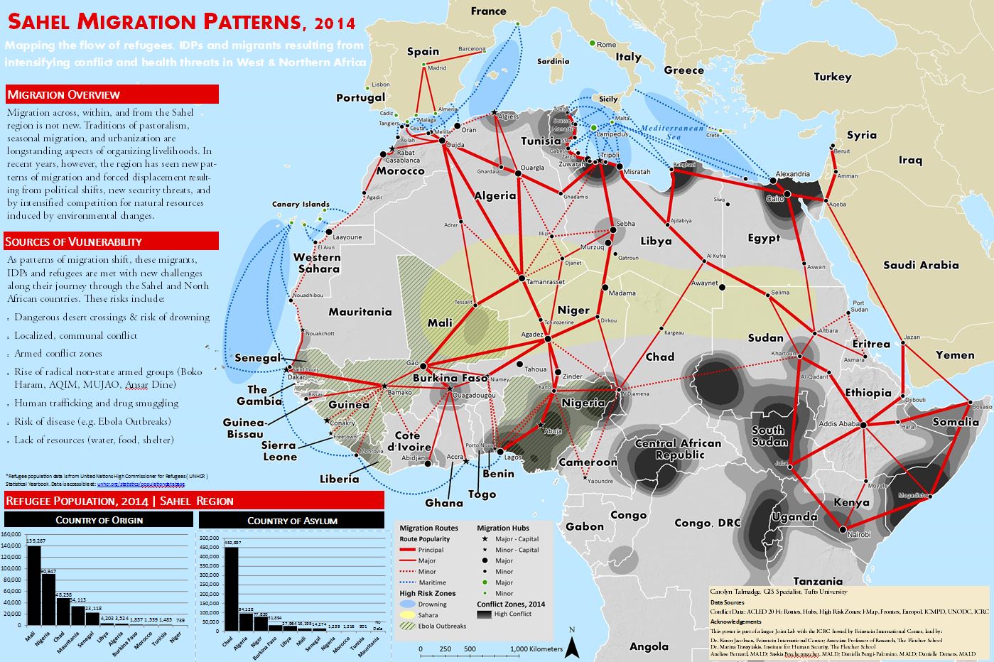 For a full list of collaborators, please see the List of Participants.
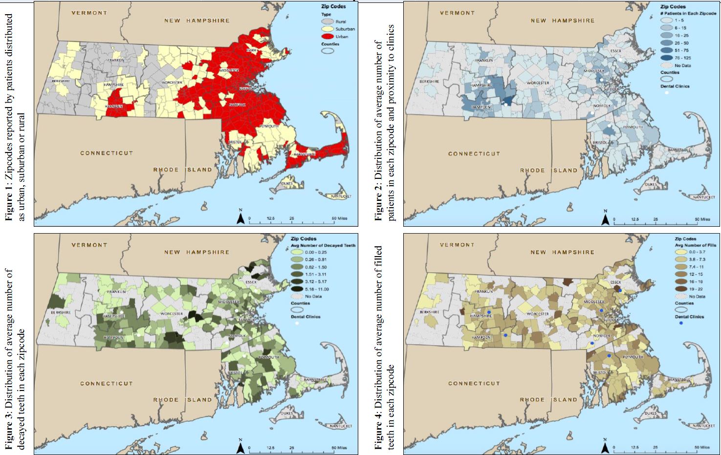
Geographic Distribution of Dental Patients with Intellectual and Developmental Disabilities
Hannah E Gilman, DMD Candidate 2016 at the Tufts University School of Dental Medicine, is working with Professor John Morgan, Tufts University School of Dental Medicine, to assess the geographic distribution of adults with IDD who received dental care at Tufts Dental Facilities (TDF) and compare their demographic and clinical status in geographical areas of Massachusetts. Below is the poster which was submitted at American Association for Dental Research Conference in March 2016. Maps were created by Carolyn Talmadge, GIS Specialist, Tufts Technology Services.
Tufts Institute of the Environment – Environmental Interdisciplinary Research Project 2016:
Grafton Campus Biodiversity Inventory – Summer 2016
The Center for Conservation Medicine at the Cumming School of Veterinary Medicine recently won a grant provided by the Tufts Institute for the Environment to conduct a Biodiversity Assessment of the Tufts Grafton Campus. The 594 acre Tufts Cummings Veterinary School Grafton Campus, located in the Blackstone River Valley National Heritage Corridor, has important habitat for wildlife. However, there has not been a systematic assessment or inventory of the species present and habitats on the campus. The goal of our project is to complete an initial inventory of the biodiversity present on the Grafton Campus, with emphasis on identifying potentially rare or threatened birds, amphibians, reptile and mammal species and their suitable habitats.
Specific aim 1) Collect presence data on avian fauna, herpetofauna, mammals and habitats on Grafton campus through field surveys
Specific aim 2) Collect data on habitats on Grafton campus through use of GPS field data collection, remote sensing data, and land cover datasets
Specific Aim 3) compile all remote sensing and GPS data to complete species and habitat inventories of the property to share and disseminate the information to all stakeholders.
Through the collection and analysis of the data we will create maps and an inventory of the campus that has never before been collected. The maps and inventory will allow faculty to predict areas for enhancement and education of the facilities managers to manage the property for the promoting education, outreach and a sustainable future for the biodiversity present on the Grafton Campus for the future generations of students and scholars within our community.
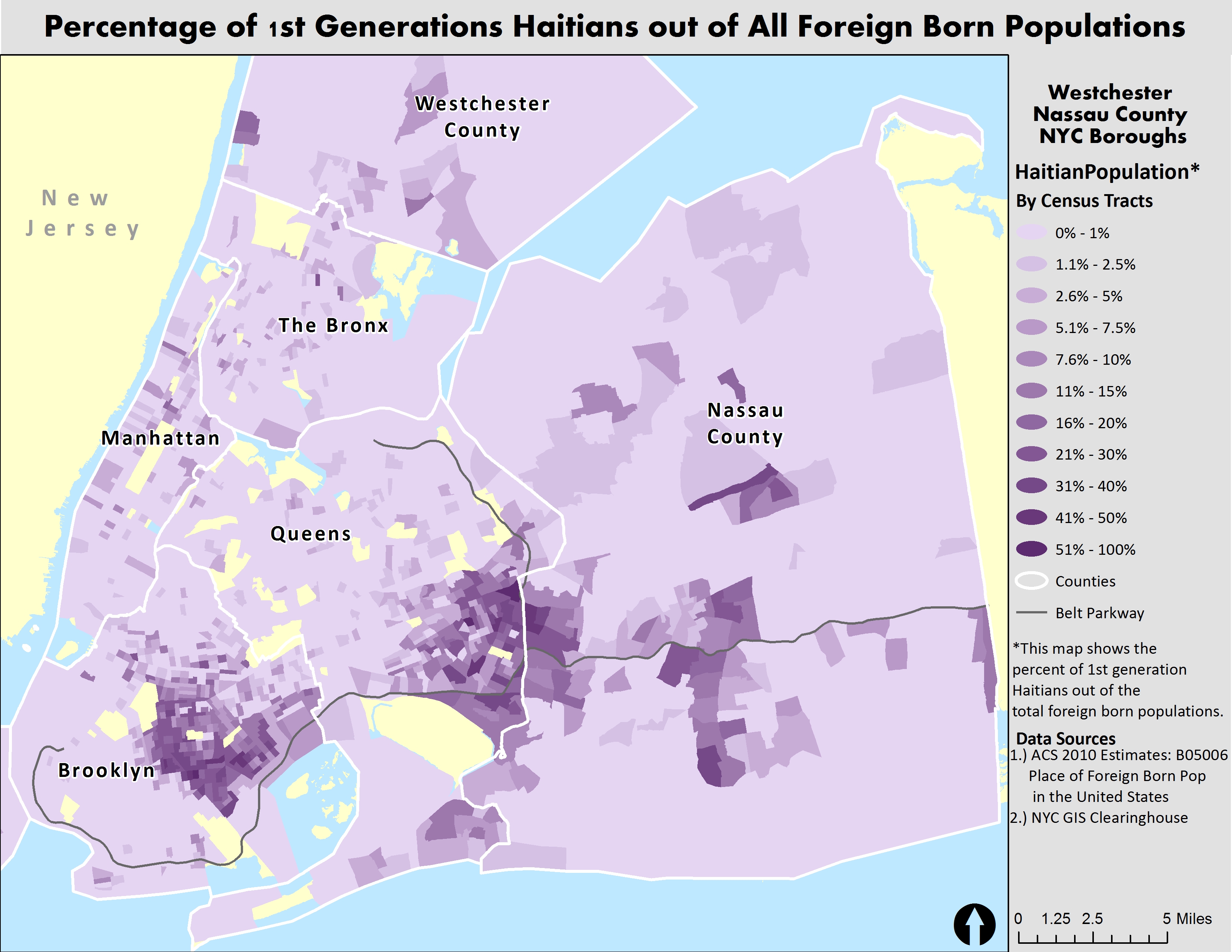
Mapping the Distribution of Jamaican and Haitian Populations within New York City – Summer 2016
Professor Orly Clergé, Assistant Professor of Sociology & Africana Studies at Tufts University, is studying the population distribution of native Jamaican and Haitians living within New York City.